


Brie/Chalais 29/11/2016

bert16
User

Length
9.8 km

Max alt
150 m

Uphill gradient
181 m
Km-Effort
12.2 km

Min alt
62 m

Downhill gradient
180 m
Boucle
Yes
Creation date :
2016-11-29 00:00:00.0
Updated on :
2016-11-29 00:00:00.0
2h38
Difficulty : Medium

FREE GPS app for hiking
 SityTrail
IGN / Geographical institutes
SityTrail Plus
The world is yours!
About
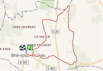
Trail Walking of 9.8 km to be discovered at New Aquitaine, Charente, Brie-sous-Chalais. This trail is proposed by bert16.
Description
chemin des crêtes
Association des anciens élèves et amis de Brie-Sous-Chalais
Positioning
Country:
France
Region :
New Aquitaine
Department/Province :
Charente
Municipality :
Brie-sous-Chalais
Location:
Unknown
Start:(Dec)
Start:(UTM)
265343 ; 5022341 (31T) N.
Comments