Trail Other activity Saint-Just-en-Chaussée - Picardie - Ligne 259 - Saint-Just-en-Chaussée - Douai (Section de St-Just à Epehy)  - Photo

Picardie - Ligne 259 - Saint-Just-en-Chaussée - Douai (Section de St-Just à Epehy)

 mich54
mich54

User

© OpenStreetMap contributors
Length
Length
94 km
Max alt
Max alt
142 m
Uphill gradient
Uphill gradient
529 m
Km-Effort
Km-Effort  
101 km
Min alt
Min alt
46 m
Downhill gradient
Downhill gradient
501 m
Boucle
Boucle
No
Creation date :
2016-12-03 00:00:00.0
Updated on :
2016-12-03 00:00:00.0

(0 Reviews)

Other activity
Other activity
5m
Difficulty : Unknown

Scan this QR Code to open this trail in the SityTrail application

FREE GPS app for hiking

Logo SityTrail SityTrail

IGN / Geographical institutes

Download SityTrail from the App Store Download SityTrail from Google Play

Logo SityTrail SityTrail World

The world is yours!

Download SityTrail from the App Store Download SityTrail from Google Play Download SityTrail on Huawei AppGallery

About

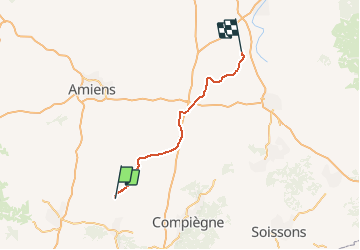
Trail Other activity of 94 km to be discovered at Hauts-de-France, Oise, Saint-Just-en-Chaussée. This trail is proposed by mich54.

Description

La ligne de Saint-Just-en-Chaussée à Douai est une ligne ferroviaire française partiellement à voie unique, reliant Saint-Just-en-Chaussée à Douai en passant par Montdidier, Péronne et Cambrai.

Partiellement déclassée entre Péronne et Cambrai, elle constitue la ligne no 259 0001 du réseau ferré national.(Source Wikipédia)

Elevation profile

Positioning

Country:
France
Region :
Hauts-de-France
Department/Province :
Oise
Municipality :
Saint-Just-en-Chaussée
Location:
Unknown
Start:(UTM)
458666 ; 5483564 (31U) N.

Trails nearby

Trail Walking Fournival - La montagne de Clermont - Photo
Walking
Mchretn

Walking

Easy
(1)
Fournival, Hauts-de-France, Oise, France
8.5 km | 10.4 km-effort
2h 15min
Yes
Trail Walking Saint-Just-en-Chaussée - 25 le val d'arré - Photo
Walking
fitz2014

Walking

Medium
Saint-Just-en-Chaussée, Hauts-de-France, Oise, France
14.3 km | 16.8 km-effort
3h 39min
Yes
Trail Walking Ravenel - Ravenel st just en chaussee en Canirando - Photo
Walking
miked60130

Walking

Very easy
Ravenel, Hauts-de-France, Oise, France
10.8 km | 12 km-effort
1h 36min
Yes
Trail Walking Saint-Just-en-Chaussée - 12 06 19 - Photo
Walking
fab1761

Walking

Very easy
Saint-Just-en-Chaussée, Hauts-de-France, Oise, France
4.2 km | 0 m-effort
56min
Yes
Trail Other activity Fournival - 2011-05-13 11h44m07 - Photo
Other activity
Mchretn

Other activity

Very easy
Fournival, Hauts-de-France, Oise, France
21 km | 24 km-effort
Unknown
No


Close
My subscriptions