


ursuya

narberd
User
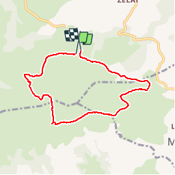

Length
7.6 km

Max alt
671 m

Uphill gradient
403 m
Km-Effort
13 km

Min alt
286 m

Downhill gradient
410 m
Boucle
Yes
Creation date :
2018-09-01 21:11:21.578
Updated on :
2018-09-01 21:11:21.596
2h27
Difficulty : Unknown

FREE GPS app for hiking
 SityTrail
IGN / Geographical institutes
SityTrail Plus
The world is yours!
About
Trail Walking of 7.6 km to be discovered at New Aquitaine, Pyrénées-Atlantiques, Hasparren. This trail is proposed by narberd.
Positioning
Country:
France
Region :
New Aquitaine
Department/Province :
Pyrénées-Atlantiques
Municipality :
Hasparren
Location:
Unknown
Start:(Dec)
Start:(UTM)
635484 ; 4801751 (30T) N.
Comments