Trail Walking Fanjeaux - GR7 E30 Fangeaux-Mirepoix - Photo

GR7 E30 Fangeaux-Mirepoix

© OpenStreetMap contributors
Length
Length
26 km
Max alt
Max alt
454 m
Uphill gradient
Uphill gradient
554 m
Km-Effort
Km-Effort  
33 km
Min alt
Min alt
292 m
Downhill gradient
Downhill gradient
605 m
Boucle
Boucle
No
Creation date :
2017-03-10 00:00:00.0
Updated on :
2017-03-10 00:00:00.0

(0 Reviews)

Walking
Walking
7h02
Difficulty : Easy

Scan this QR Code to open this trail in the SityTrail application

FREE GPS app for hiking

Logo SityTrail SityTrail

IGN / Geographical institutes

Download SityTrail from the App Store Download SityTrail from Google Play

Logo SityTrail SityTrail World

The world is yours!

Download SityTrail from the App Store Download SityTrail from Google Play Download SityTrail on Huawei AppGallery

About

Trail Walking of 26 km to be discovered at Occitania, Aude, Fanjeaux. This trail is proposed by richard21220.

Description

Hôtels à 09500 MIREPOIX Tél OT 05 61 68 83 76
Chambres d'Hôtes : Larché 09500 MIREPOIX Tél 06 77 39 84 23

Elevation profile

Positioning

Country:
France
Region :
Occitania
Department/Province :
Aude
Municipality :
Fanjeaux
Location:
Unknown
Start:(UTM)
421566 ; 4782054 (31T) N.

Trails nearby

Trail Walking Lasserre-de-Prouille - Lasserre de prouilhe 17 kms - Photo
Walking
cappelle

Walking

Medium
(1)
Lasserre-de-Prouille, Occitania, Aude, France
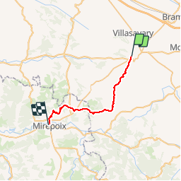
16.9 km | 21 km-effort
4h 25min
Yes
Trail Walking Fanjeaux - Fanjeaux la hilhe - Photo
Walking
cappelle

Walking

Difficult
(1)
Fanjeaux, Occitania, Aude, France
9.7 km | 13.2 km-effort
3h 0min
No
Trail Mountain bike Villasavary - circuit 3 villasavary - Photo
Mountain bike
leroj73

Mountain bike

Medium
(1)
Villasavary, Occitania, Aude, France
23 km | 30 km-effort
1h 43min
Yes
Trail Walking Laurac - Laurac Fanjeaux - Photo
Walking
tracegps

Walking

Very difficult
(1)
Laurac, Occitania, Aude, France
27 km | 37 km-effort
6h 30min
Yes
Trail Walking Fanjeaux - Fanjeaux  Boucle de la Hille  - Photo
Walking
Mamilaure

Walking

Medium
Fanjeaux, Occitania, Aude, France
13.1 km | 18.3 km-effort
3h 30min
Yes
Trail On foot Ferran - À travers Champs et Vignes - Photo
On foot
PRO

On foot

Medium
Ferran, Occitania, Aude, France
17.2 km | 21 km-effort
4h 49min
Yes
Trail Walking Fanjeaux - Chemin du Piémont Pyrénéen - de Fanjeaux à Mirepoix - Photo
Walking
tracegps

Walking

Difficult
(1)
Fanjeaux, Occitania, Aude, France
26 km | 33 km-effort
6h 0min
No
Trail Walking Fanjeaux - 2023 09 16 CHEMIN du PIÉMONT PYRÉNÉEN - 9ème étapes :  FANGEAUX - HOUNOUX - MALEGOUDE - MIREPOIX - Photo
Walking
LEGUE

Walking

Difficult
Fanjeaux, Occitania, Aude, France
25 km | 33 km-effort
4h 51min
No
Trail Walking Villasavary - Villasavary - Photo
Walking
Christophe Ferreres

Walking

Medium
Villasavary, Occitania, Aude, France
7.8 km | 10.4 km-effort
3h 3min
Yes


Close
My subscriptions