Trail Walking Chalabre - GR7 E32  Chalabre-Puivert - Photo

GR7 E32 Chalabre-Puivert

© OpenStreetMap contributors
Length
Length
18.8 km
Max alt
Max alt
761 m
Uphill gradient
Uphill gradient
601 m
Km-Effort
Km-Effort  
26 km
Min alt
Min alt
375 m
Downhill gradient
Downhill gradient
496 m
Boucle
Boucle
No
Creation date :
2017-03-10 00:00:00.0
Updated on :
2017-03-10 00:00:00.0

(0 Reviews)

Walking
Walking
5h38
Difficulty : Very easy

Scan this QR Code to open this trail in the SityTrail application

FREE GPS app for hiking

Logo SityTrail SityTrail

IGN / Geographical institutes

Download SityTrail from the App Store Download SityTrail from Google Play

Logo SityTrail SityTrail World

The world is yours!

Download SityTrail from the App Store Download SityTrail from Google Play Download SityTrail on Huawei AppGallery

About

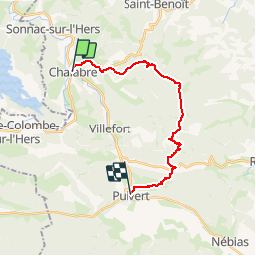
Trail Walking of 18.8 km to be discovered at Occitania, Aude, Chalabre. This trail is proposed by richard21220.

Description

Gîte et Chambres d'Hôtes La Peyrouse : La Peyrouse 11230 PUIVERT Tél 04 68 20 24 19

Chambres d'Hôtes La Métairie d'en Bor : 11230 PUIVERT Tél 06 73 39 87 80

Gîte d'Etape le Relais des Marionnettes : 19 route Départementale 117 11230 PUIVERT Tél 04 68 20 80 69

Chambres d'Hôtes Au Petit Verger : 8 route Départementale 117 11230 PUIVERT Tél 04 68 20 66 08

Chambres d'Hôtes Domaine Antonin : Camp Sylvestre 11230 PUIVERT Tél 04 68 20 80 27

Chambres d'Hôtes La Cocagnière : 3 place du Pijol Camp Sylvestre 11230 PUIVERT Tél 04 68 20 81 90

Elevation profile

Positioning

Country:
France
Region :
Occitania
Department/Province :
Aude
Municipality :
Chalabre
Location:
Unknown
Start:(UTM)
419012 ; 4759338 (31T) N.

Trails nearby

Trail Walking Rivel - Au fil de l'eau - Rivel - Photo
Walking
tracegps

Walking

Medium
(1)
Rivel, Occitania, Aude, France
5.2 km | 7 km-effort
1h 45min
Yes
Trail Walking Rivel - Le chemin du château - Rivel - Photo
Walking
tracegps

Walking

Easy
(1)
Rivel, Occitania, Aude, France
2.4 km | 4 km-effort
45min
Yes
Trail Walking Montbel - Lac de Montbel - Photo
Walking
tracegps

Walking

Medium
(2)
Montbel, Occitania, Ariège, France
15.8 km | 18.4 km-effort
3h 19min
Yes
Trail On foot Montbel - Tour du Lac de Montbel - Photo
On foot
PRO

On foot

Easy
Montbel, Occitania, Ariège, France
15.3 km | 17.9 km-effort
4h 4min
Yes
Trail Cycle Chalabre - Chalabre - Limoux - Espéraza - Photo
Cycle
tracegps

Cycle

Difficult
Chalabre, Occitania, Aude, France
72 km | 88 km-effort
4h 30min
Yes
Trail Equestrian Chalabre - La colline du calvaire - Chalabre - Photo
Equestrian
tracegps

Equestrian

Easy
Chalabre, Occitania, Aude, France
4.4 km | 6.4 km-effort
1h 0min
Yes
Trail Walking Chalabre - La colline du calvaire - Chalabre - Photo
Walking
tracegps

Walking

Easy
Chalabre, Occitania, Aude, France
4.4 km | 6.4 km-effort
1h 30min
Yes
Trail Walking Chalabre - Circuit de découverte de Chalabre - Photo
Walking
tracegps

Walking

Easy
Chalabre, Occitania, Aude, France
3.5 km | 3.9 km-effort
1h 0min
Yes
Trail Equestrian Chalabre - Histoires d'eau et de train - Chalabre - Photo
Equestrian
tracegps

Equestrian

Difficult
Chalabre, Occitania, Aude, France
23 km | 28 km-effort
4h 0min
Yes


Close
My subscriptions