


Lac de Curtales 2011 07 03

psesjs
User
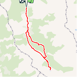

Length
15.7 km

Max alt
2446 m

Uphill gradient
748 m
Km-Effort
26 km

Min alt
1748 m

Downhill gradient
748 m
Boucle
Yes
Creation date :
2014-12-10 00:00:00.0
Updated on :
2014-12-10 00:00:00.0
--
Difficulty : Difficult

FREE GPS app for hiking
 SityTrail
IGN / Geographical institutes
SityTrail Plus
The world is yours!
About
Trail Walking of 15.7 km to be discovered at Auvergne-Rhône-Alpes, Savoy, Valmeinier. This trail is proposed by psesjs.
Positioning
Country:
France
Region :
Auvergne-Rhône-Alpes
Department/Province :
Savoy
Municipality :
Valmeinier
Location:
Unknown
Start:(Dec)
Start:(UTM)
303079 ; 5003984 (32T) N.
Comments