Trail Winter sports Curières -

"Puy" Gurdettes

© OpenStreetMap contributors
Length
Length
9 km
Max alt
Max alt
1398 m
Uphill gradient
Uphill gradient
288 m
Km-Effort
Km-Effort  
12.8 km
Min alt
Min alt
1237 m
Downhill gradient
Downhill gradient
299 m
Boucle
Boucle
No
Creation date :
2014-12-10 00:00:00.0
Updated on :
2014-12-10 00:00:00.0

(0 Reviews)

Winter sports
Winter sports
--
Difficulty : Unknown

Scan this QR Code to open this trail in the SityTrail application

FREE GPS app for hiking

Logo SityTrail SityTrail

IGN / Geographical institutes

Download SityTrail from the App Store Download SityTrail from Google Play

Logo SityTrail SityTrail World

The world is yours!

Download SityTrail from the App Store Download SityTrail from Google Play Download SityTrail on Huawei AppGallery

About

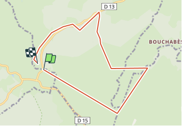
Trail Winter sports of 9 km to be discovered at Occitania, Aveyron, Curières. This trail is proposed by bonnetchristian.

Description

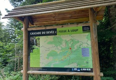
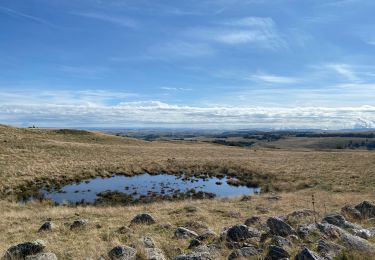
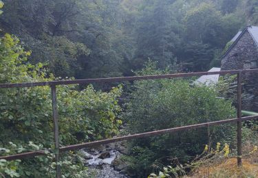
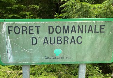
Aubrac en hiver ( Janvier- Février )Traversées forestières peu difficiles
POI : Buvettes en saison
Parking parfois compliqué à cause de la neige....

Elevation profile

Positioning

Country:
France
Region :
Occitania
Department/Province :
Aveyron
Municipality :
Curières
Location:
Unknown
Start:(UTM)
496766 ; 4945086 (31T) N.

Trails nearby

Trail Walking Saint-Chély-d'Aubrac - Aubrac - St Côme d'Olt - Chemin de St-Jacques de Compostelle - Photo
Walking
tracegps

Walking

Very difficult
(1)
Saint-Chély-d'Aubrac, Occitania, Aveyron, France
23 km | 30 km-effort
5h 0min
No
Trail Walking Curières - Le Devez cascade et forêts  - Photo
Walking
GUIDE
nadinebondoux

Walking

Easy
Curières, Occitania, Aveyron, France
11 km | 15.4 km-effort
3h 22min
Yes
Trail On foot Nasbinals - chemin de Saint-Jacques-de-Compostelle pour randonneurs avec animaux (chien, ane, cheval) ou VTT - Photo
On foot
PRO

On foot

Easy
Nasbinals, Occitania, Lozère, France
5.7 km | 7.3 km-effort
1h 38min
No
Trail Walking Laguiole - Laguiole - Station de ski - Photo
Walking
neitag61

Walking

Medium
(1)
Laguiole, Occitania, Aveyron, France
7.1 km | 9.5 km-effort
1h 50min
Yes
Trail Walking Saint-Urcize - Des estives et des croix  - Photo
Walking
GUIDE
antignacs

Walking

Easy
Saint-Urcize, Auvergne-Rhône-Alpes, Cantal, France
19.8 km | 25 km-effort
5h 19min
Yes
Trail Walking Saint-Urcize - Carbonade Croix de Goutal  - Photo
Walking
GUIDE
antignacs

Walking

Very easy
Saint-Urcize, Auvergne-Rhône-Alpes, Cantal, France
9.5 km | 12.4 km-effort
2h 37min
Yes
Trail Walking Saint-Chély-d'Aubrac - Compostelle / Chemin du Puy : de Aubrac à Bonneval - Photo
Walking
webmammuth

Walking

Difficult
Saint-Chély-d'Aubrac, Occitania, Aveyron, France
33 km | 46 km-effort
11h 0min
No
Trail Walking Curières - Cascade du devèz et fosse à loup - Photo
Walking
GUIDE
Roger Philippe Wallez

Walking

Difficult
Curières, Occitania, Aveyron, France
10.8 km | 15 km-effort
4h 7min
Yes
Trail Walking Laguiole - Bouyssou sous la neige  - Photo
Walking
GUIDE
antignacs

Walking

Very easy
Laguiole, Occitania, Aveyron, France
6.3 km | 7.5 km-effort
2h 2min
Yes


Close
My subscriptions