Trail Other activity Pont-l'Évêque - Basse Normandie - Ligne 377 - Pont-l'Evêque - Honfleur - Photo

Basse Normandie - Ligne 377 - Pont-l'Evêque - Honfleur

 mich54
mich54

User

© OpenStreetMap contributors
Length
Length
23 km
Max alt
Max alt
146 m
Uphill gradient
Uphill gradient
255 m
Km-Effort
Km-Effort  
27 km
Min alt
Min alt
8 m
Downhill gradient
Downhill gradient
259 m
Boucle
Boucle
No
Creation date :
2017-01-20 00:00:00.0
Updated on :
2017-01-20 00:00:00.0

(0 Reviews)

Other activity
Other activity
5m
Difficulty : Unknown

Scan this QR Code to open this trail in the SityTrail application

FREE GPS app for hiking

Logo SityTrail SityTrail

IGN / Geographical institutes

Download SityTrail from the App Store Download SityTrail from Google Play

Logo SityTrail SityTrail World

The world is yours!

Download SityTrail from the App Store Download SityTrail from Google Play Download SityTrail on Huawei AppGallery

About

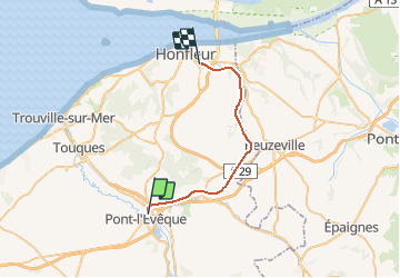
Trail Other activity of 23 km to be discovered at Normandy, Calvados, Pont-l'Évêque. This trail is proposed by mich54.

Description

La ligne de Pont-l'Évêque à Honfleur est une ligne de chemin de fer française à écartement standard et à voie unique non électrifiée. Elle relie Honfleur à Lisieux par Pont-l'Évêque. Seule une section de la ligne est ouverte pour le fret.Le 26 septembre 1971, la ligne est fermée au trafic voyageurs. Le 1er juin 1975, le trafic cesse officiellement sur la section entre Pont-l'Evêque et Quetteville qui est déclassée par un décret du 11 juillet 1994.(Source Wikipédia)

Elevation profile

Positioning

Country:
France
Region :
Normandy
Department/Province :
Calvados
Municipality :
Pont-l'Évêque
Location:
Pont-l'Évêque
Start:(UTM)
295568 ; 5463522 (31U) N.

Trails nearby

Trail Walking Pont-l'Évêque - Lac de Pont l'Évêque  - Photo
Walking
tracegps

Walking

Difficult
(3)
Pont-l'Évêque, Normandy, Calvados, France
14.8 km | 18.9 km-effort
4h 10min
Yes
Trail Walking Reux - La croix de fer - Photo
Walking
neoroll44

Walking

Easy
(2)
Reux, Normandy, Calvados, France
5.7 km | 6.2 km-effort
1h 30min
No
Trail Walking Saint-Hymer - St Hymer - Photo
Walking
Eve - Line

Walking

Medium
Saint-Hymer, Normandy, Calvados, France
12.6 km | 15.3 km-effort
2h 49min
Yes
Trail Walking Pierrefitte-en-Auge - Pierrefitte-en-Auge - Photo
Walking
gr1346

Walking

Medium
(1)
Pierrefitte-en-Auge, Normandy, Calvados, France
15 km | 18.6 km-effort
4h 3min
Yes
Trail Mountain bike Pont-l'Évêque - Rando Pont l'Evèque - Photo
Mountain bike
tracegps

Mountain bike

Difficult
Pont-l'Évêque, Normandy, Calvados, France
32 km | 39 km-effort
2h 30min
Yes
Trail Walking Pont-l'Évêque - Rando Pont l'Evèque - Photo
Walking
tracegps

Walking

Difficult
Pont-l'Évêque, Normandy, Calvados, France
32 km | 39 km-effort
6h 0min
Yes
Trail Walking Vieux-Bourg - Vieux Bourg - Photo
Walking
Eve - Line

Walking

Medium
Vieux-Bourg, Normandy, Calvados, France
12.3 km | 15.8 km-effort
3h 10min
Yes
Trail Mountain bike Pont-l'Évêque - 32 km VTT avec Denys  - Photo
Mountain bike
Marc Girard

Mountain bike

Pont-l'Évêque, Normandy, Calvados, France
32 km | 38 km-effort
2h 55min
No
Trail Mountain bike Saint-Hymer - De Saint - Hymer à Clarbec - Photo
Mountain bike
tracegps

Mountain bike

Difficult
Saint-Hymer, Normandy, Calvados, France
34 km | 41 km-effort
2h 30min
Yes


Close
My subscriptions