


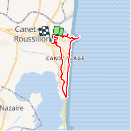
RP66 CANET EN ROUSSILLON - LE PORT - FRONT DE MER - Village - le 10.02.2017

jeff66
User

Length
11.6 km

Max alt
12 m

Uphill gradient
55 m
Km-Effort
12.3 km

Min alt
-2 m

Downhill gradient
55 m
Boucle
Yes
Creation date :
2017-02-10 00:00:00.0
Updated on :
2017-02-10 00:00:00.0
2h20
Difficulty : Easy

FREE GPS app for hiking
 SityTrail
IGN / Geographical institutes
SityTrail Plus
The world is yours!
About
Trail Walking of 11.6 km to be discovered at Occitania, Pyrénées-Orientales, Canet-en-Roussillon. This trail is proposed by jeff66.
Description
RP66 CANET EN ROUSSILLON - LE PORT - FRONT DE MER - Village - le 10.02.2017
Positioning
Country:
France
Region :
Occitania
Department/Province :
Pyrénées-Orientales
Municipality :
Canet-en-Roussillon
Location:
Unknown
Start:(Dec)
Start:(UTM)
501917 ; 4727496 (31T) N.
Comments