


sortie vtt du 12022017

fabwin
User GUIDE
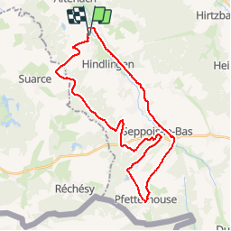

Length
33 km

Max alt
447 m

Uphill gradient
421 m
Km-Effort
39 km

Min alt
327 m

Downhill gradient
420 m
Boucle
Yes
Creation date :
2017-02-16 00:00:00.0
Updated on :
2017-02-16 00:00:00.0
2h04
Difficulty : Easy

FREE GPS app for hiking
 SityTrail
IGN / Geographical institutes
SityTrail Plus
The world is yours!
About
Trail Mountain bike of 33 km to be discovered at Grand Est, Haut-Rhin, Mertzen. This trail is proposed by fabwin.
Description
Sortie sous le soleil avec papa & Ange.
Ange a pédalé un peu plus que nous dû au fait que le frein avant du Spé freinait en permanence!!!
Positioning
Country:
France
Region :
Grand Est
Department/Province :
Haut-Rhin
Municipality :
Mertzen
Location:
Unknown
Start:(Dec)
Start:(UTM)
358944 ; 5272168 (32T) N.
Comments