Valmeinier 1800 Meraloup

psesjs
User
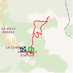

Length
8.8 km

Max alt
2173 m

Uphill gradient
422 m
Km-Effort
14.4 km

Min alt
1765 m

Downhill gradient
423 m
Boucle
Yes
Creation date :
2014-12-10 00:00:00.0
Updated on :
2014-12-10 00:00:00.0
3h00
Difficulty : Very easy

FREE GPS app for hiking
 SityTrail
IGN / Geographical institutes
SityTrail Plus
The world is yours!
About
Trail Walking of 8.8 km to be discovered at Auvergne-Rhône-Alpes, Savoy, Valmeinier. This trail is proposed by psesjs.


Positioning
Country:
France
Region :
Auvergne-Rhône-Alpes
Department/Province :
Savoy
Municipality :
Valmeinier
Location:
Unknown
Start:(Dec)
Start:(UTM)
303047 ; 5005425 (32T) N.
Comments