Trail Walking Suresnes - Mont Valérien 8.4 km - Photo

Mont Valérien 8.4 km

© OpenStreetMap contributors
Length
Length
8.4 km
Max alt
Max alt
124 m
Uphill gradient
Uphill gradient
66 m
Km-Effort
Km-Effort  
9.6 km
Min alt
Min alt
28 m
Downhill gradient
Downhill gradient
153 m
Boucle
Boucle
No
Creation date :
2017-02-22 00:00:00.0
Updated on :
2017-02-22 00:00:00.0

(0 Reviews)

Walking
Walking
2h03
Difficulty : Medium

Scan this QR Code to open this trail in the SityTrail application

FREE GPS app for hiking

Logo SityTrail SityTrail

IGN / Geographical institutes

Download SityTrail from the App Store Download SityTrail from Google Play

Logo SityTrail SityTrail World

The world is yours!

Download SityTrail from the App Store Download SityTrail from Google Play Download SityTrail on Huawei AppGallery

About

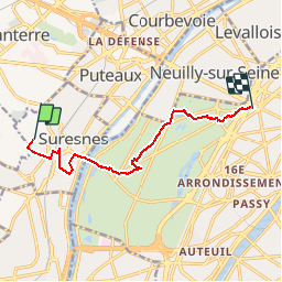
Trail Walking of 8.4 km to be discovered at Ile-de-France, Hauts-de-Seine, Suresnes. This trail is proposed by GOELERANDO2.

Description

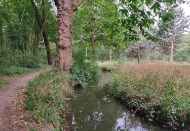
Départ du Mont Valérien vers la Porte Maillot par le Bois de Boulogne.

Elevation profile

Positioning

Country:
France
Region :
Ile-de-France
Department/Province :
Hauts-de-Seine
Municipality :
Suresnes
Location:
Unknown
Start:(UTM)
442319 ; 5413406 (31U) N.

Trails nearby

Trail Walking Paris - DP75-11 De Boulainvilliers à pont du Garigliano - Photo
Walking
clalaur

Walking

Easy
(1)
Paris, Ile-de-France, Paris, France
4.7 km | 5.4 km-effort
1h 13min
No
Trail Cycle Paris - Paris au bord de Seine - Photo
Cycle
aurel911

Cycle

Very easy
(1)
Paris, Ile-de-France, Paris, France
11.4 km | 14.2 km-effort
46min
No
Trail Walking Paris - 75-04-Paris les Ponts 13km-493-55- - Photo
Walking
rvs147

Walking

Easy
(1)
Paris, Ile-de-France, Paris, France
13.1 km | 16.3 km-effort
3h 22min
No
Trail Walking Boulogne-Billancourt - Parc de St Cloud et forêt de Fausses Reposes - Photo
Walking
tracegps

Walking

Medium
(1)
Boulogne-Billancourt, Ile-de-France, Hauts-de-Seine, France
18.2 km | 23 km-effort
4h 30min
No
Trail Walking Paris - SityTrail - 007 - Paris - D'Auteuil à st Michel - 8/10 - Photo
Walking
GUIDE
Rui Barbosa

Walking

Difficult
(1)
Paris, Ile-de-France, Paris, France
11.1 km | 13.8 km-effort
3h 8min
No
Trail On foot Rueil-Malmaison - SityTrail - 3850997 - rando-chatou (1) - Photo
On foot
chessyca

On foot

Medium
Rueil-Malmaison, Ile-de-France, Hauts-de-Seine, France
32 km | 37 km-effort
8h 22min
No
Trail Walking Vaucresson - GRP CV-IDF 2023 - Photo
Walking
clalaur

Walking

Easy
Vaucresson, Ile-de-France, Hauts-de-Seine, France
11.9 km | 15.3 km-effort
3h 29min
No
Trail Walking Paris - DP75-12 De pont du garigliano à Vaugirard - Photo
Walking
clalaur

Walking

Easy
Paris, Ile-de-France, Paris, France
5.5 km | 6.4 km-effort
1h 26min
No
Trail Walking Neuilly-sur-Seine - Le bois de Boulogne - Photo
Walking
c.chehere

Walking

Easy
Neuilly-sur-Seine, Ile-de-France, Hauts-de-Seine, France
14.8 km | 16.6 km-effort
4h 33min
No


Close
My subscriptions