


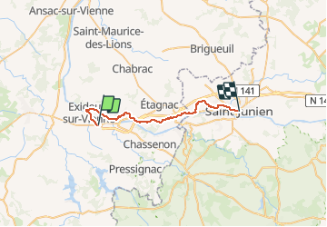
Exideuil Saint Junien

legereric
User

Length
28 km

Max alt
235 m

Uphill gradient
410 m
Km-Effort
33 km

Min alt
146 m

Downhill gradient
381 m
Boucle
No
Creation date :
2014-12-10 00:00:00.0
Updated on :
2014-12-10 00:00:00.0
--
Difficulty : Medium

FREE GPS app for hiking
 SityTrail
IGN / Geographical institutes
SityTrail Plus
The world is yours!
About
Trail Walking of 28 km to be discovered at New Aquitaine, Charente, Exideuil-sur-Vienne. This trail is proposed by legereric.
Description
d'Exideuil à saint Junien vallée de la Vienne
Positioning
Country:
France
Region :
New Aquitaine
Department/Province :
Charente
Municipality :
Exideuil-sur-Vienne
Location:
Unknown
Start:(Dec)
Start:(UTM)
320573 ; 5082575 (31T) N.
Comments