RP66 - MILLAS LES PLANS D'EAU - le 24.02.2017

jeff66
User
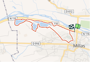

Length
4.9 km

Max alt
111 m

Uphill gradient
34 m
Km-Effort
5.4 km

Min alt
94 m

Downhill gradient
34 m
Boucle
Yes
Creation date :
2017-02-27 00:00:00.0
Updated on :
2017-02-27 00:00:00.0
59m
Difficulty : Easy

FREE GPS app for hiking
 SityTrail
IGN / Geographical institutes
SityTrail Plus
The world is yours!
About
Trail Walking of 4.9 km to be discovered at Occitania, Pyrénées-Orientales, Millas. This trail is proposed by jeff66.
Description
RP66 - MILLAS LES PLANS D'EAU - le 24.02.2017
Positioning
Country:
France
Region :
Occitania
Department/Province :
Pyrénées-Orientales
Municipality :
Millas
Location:
Unknown
Start:(Dec)
Start:(UTM)
475088 ; 4727055 (31T) N.
Comments