


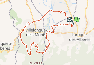
RP66 LAROQUE - domaine des ALBERES - piste DFCI AL9 - VILLELONGUE DELS Monts - piste DFCI AL7 - ST GÉNIS DES F. - le 27.02.2017

jeff66
User


2h24
Difficulty : Medium

FREE GPS app for hiking
 SityTrail
IGN / Geographical institutes
SityTrail Plus
The world is yours!
About
Trail Walking of 12.2 km to be discovered at Occitania, Pyrénées-Orientales, Laroque-des-Albères. This trail is proposed by jeff66.
Description
RP66 LAROQUE - les Vernèdes - Les Planes - domaine des ALBERES - piste DFCI AL9 - MAS d'en Badia - VILLLELONGUE DELS Monts - Cami del Pinetell - Cami del Vilar - piste DFCI AL7 - Mas d'en Pepet et Tambor - Cami de Matemala - rues du 8 Mai, Des Alzines, Cami de la Falgor et De les Closes - ST GÉNIS DES F. - Reixac - le 27.02.2017
Positioning
Comments