


Pic Carlit par le lac des Bouillouses

Axelloceane
User
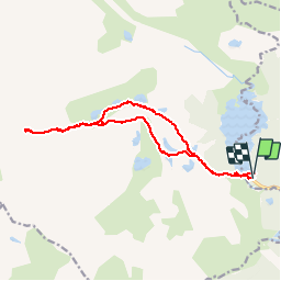

Length
16.6 km

Max alt
2886 m

Uphill gradient
927 m
Km-Effort
29 km

Min alt
2003 m

Downhill gradient
932 m
Boucle
Yes
Creation date :
2014-12-10 00:00:00.0
Updated on :
2014-12-10 00:00:00.0
--
Difficulty : Difficult

FREE GPS app for hiking
 SityTrail
IGN / Geographical institutes
SityTrail Plus
The world is yours!
About
Trail Walking of 16.6 km to be discovered at Occitania, Pyrénées-Orientales, Les Angles. This trail is proposed by Axelloceane.
Positioning
Country:
France
Region :
Occitania
Department/Province :
Pyrénées-Orientales
Municipality :
Les Angles
Location:
Unknown
Start:(Dec)
Start:(UTM)
418183 ; 4712461 (31T) N.
Comments