![](/images/other/stat-length.png)
![Trail Walking Narbonne - La_Forêt_de_Fonfroide - Photo](https://media.geolcdn.com/t/1900/400/ext.pjpeg?maxdim=2&url=https%3A%2F%2Fstatic1.geolcdn.com%2Fsiteimages%2Fupload%2Ffiles%2F1553511878bg_sport_marche.png)
La_Forêt_de_Fonfroide
cbouttes
User
![Length](/images/other/stat-length.png)
Length
6.9 km
![Max alt](https://static1.geolcdn.com/siteimages/upload/files/1508320355ic_sort_altitude_max_24dp.png)
Max alt
239 m
![Uphill gradient](https://static1.geolcdn.com/siteimages/upload/files/1508320355ic_sort_den_pos_24dp.png)
Uphill gradient
206 m
![Km-Effort](/images/other/stat-length.png)
Km-Effort
9.7 km
![Min alt](https://static1.geolcdn.com/siteimages/upload/files/1508320355ic_sort_altitude_min_24dp.png)
Min alt
100 m
![Downhill gradient](https://static1.geolcdn.com/siteimages/upload/files/1508320355ic_sort_den_neg_24dp.png)
Downhill gradient
208 m
![Boucle](https://static1.geolcdn.com/siteimages/upload/files/16400158638029165_repeat_loop_refresh_sync_direction_icon.png)
Boucle
Yes
Creation date :
2017-03-11 00:00:00.0
Updated on :
2017-03-11 00:00:00.0
![Walking](https://static1.geolcdn.com/sitytour/trail-icons/101.png)
2h05
Difficulty : Unknown
![Scan this QR Code to open this trail in the SityTrail application](https://capi.geolives.com/qq0zvz2zws4bq2lad0pu/sitytour/trails/711779/qr.png?size=200)
FREE GPS app for hiking
About
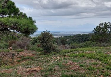
Trail Walking of 6.9 km to be discovered at Occitania, Aude, Narbonne. This trail is proposed by cbouttes.
Description
Distance : 6.936 kmAltitudes : Maxi 232 m Mini 99 mDénivelées : ~ 121 m -161 mType de trace : Pedestrehttps://www.gpx-view.com/gpx.php?f=00113__La_Foreit_de_Fonfroide.gpx
Positioning
Country:
France
Region :
Occitania
Department/Province :
Aude
Municipality :
Narbonne
Location:
Unknown
Start:(Dec)
Start:(UTM)
491764 ; 4775048 (31T) N.
Comments
Trails nearby
![Trail Other activity Bizanet - Abbaye de Fontdefroide - Photo](https://media.geolcdn.com/t/375/260/ext.jpg?maxdim=2&url=https%3A%2F%2Fservices.sitytrail.com%2FGeolivesWS%2FDownloadMedia.ashx%3FTrailID%3D458985%26Media%3D20150814175939.jpg)
![Other activity Other activity](https://static1.geolcdn.com/sitytour/trail-icons/900.png)
Abbaye de Fontdefroide
Other activity
Medium
(3)
Bizanet,
Occitania,
Aude,
France
![](/images/other/stat-length.png)
20 km | 26 km-effort
2h 13min
![](https://static1.geolcdn.com/siteimages/upload/files/16400158638029165_repeat_loop_refresh_sync_direction_icon.png)
Yes
![Trail Walking Narbonne - L'Aragnon de Frontfroide - Photo](https://media.geolcdn.com/t/375/260/ext.jpg?maxdim=2&url=https%3A%2F%2Fstatic1.geolcdn.com%2Fsiteimages%2Fupload%2Ffiles%2F1553511878bg_sport_marche.png)
![Walking Walking](https://static1.geolcdn.com/sitytour/trail-icons/101.png)
L'Aragnon de Frontfroide
Walking
Very easy
(1)
Narbonne,
Occitania,
Aude,
France
![](/images/other/stat-length.png)
8.7 km | 10.9 km-effort
2h 24min
![](https://static1.geolcdn.com/siteimages/upload/files/16400158638029165_repeat_loop_refresh_sync_direction_icon.png)
Yes
![Trail Walking Narbonne - La combe d'enfer en Narbonnais - Photo](https://media.geolcdn.com/t/375/260/ext.jpg?maxdim=2&url=https%3A%2F%2Fmedia.geolcdn.com%2Ff%2F28cc313a-8a47-482c-81b5-28081d16a224.jpg)
![Walking Walking](https://static1.geolcdn.com/sitytour/trail-icons/101.png)
La combe d'enfer en Narbonnais
Walking
Easy
Narbonne,
Occitania,
Aude,
France
![](/images/other/stat-length.png)
15.9 km | 21 km-effort
4h 30min
![](https://static1.geolcdn.com/siteimages/upload/files/16400158638029165_repeat_loop_refresh_sync_direction_icon.png)
Yes
![Trail Walking Narbonne - Fontfroide (aude) Près de Narbonne - Photo](https://media.geolcdn.com/t/375/260/ext.jpg?maxdim=2&url=https%3A%2F%2Fmedia.geolcdn.com%2Ff%2F740c9163-f8f4-4dac-b59d-2c6335707879.jpg)
![Walking Walking](https://static1.geolcdn.com/sitytour/trail-icons/101.png)
Fontfroide (aude) Près de Narbonne
Walking
Easy
(1)
Narbonne,
Occitania,
Aude,
France
![](/images/other/stat-length.png)
17.2 km | 22 km-effort
5h 15min
![](https://static1.geolcdn.com/siteimages/upload/files/16400158638029165_repeat_loop_refresh_sync_direction_icon.png)
Yes
![Trail Walking Bages - Prat-de-Cest - Abbaye de Fontfroide - Photo](https://media.geolcdn.com/t/375/260/ext.jpg?maxdim=2&url=https%3A%2F%2Fmedia.geolcdn.com%2Ff%2Ffd3516f0-d21c-487d-b7cc-d412f56ad9ce.jpg)
![Walking Walking](https://static1.geolcdn.com/sitytour/trail-icons/101.png)
Prat-de-Cest - Abbaye de Fontfroide
Walking
Medium
Bages,
Occitania,
Aude,
France
![](/images/other/stat-length.png)
14.3 km | 19.2 km-effort
4h 10min
![](https://static1.geolcdn.com/siteimages/upload/files/16400158638029165_repeat_loop_refresh_sync_direction_icon.png)
Yes
![Trail Walking Bizanet - Bizanet - Photo](https://media.geolcdn.com/t/375/260/ext.jpg?maxdim=2&url=https%3A%2F%2Fservices.sitytrail.com%2FGeolivesWS%2FDownloadMedia.ashx%3FTrailID%3D172253%26Media%3D8562_5.jpg)
![Walking Walking](https://static1.geolcdn.com/sitytour/trail-icons/101.png)
![Trail Walking Narbonne - Narbonne Etang De Jonquières - Photo](https://media.geolcdn.com/t/375/260/ext.jpg?maxdim=2&url=https%3A%2F%2Fservices.sitytrail.com%2FGeolivesWS%2FDownloadMedia.ashx%3FTrailID%3D121016%26Media%3D20120410133338.jpg)
![Walking Walking](https://static1.geolcdn.com/sitytour/trail-icons/101.png)
Narbonne Etang De Jonquières
Walking
Easy
Narbonne,
Occitania,
Aude,
France
![](/images/other/stat-length.png)
8.1 km | 9.8 km-effort
1h 25min
![](https://static1.geolcdn.com/siteimages/upload/files/16400158638029165_repeat_loop_refresh_sync_direction_icon.png)
Yes
![Trail Walking Peyriac-de-Mer - peyriac de mer . étang de doul . roc de vidal . pêche rouge . croix St Paul. peyriac - Photo](https://media.geolcdn.com/t/375/260/ext.jpg?maxdim=2&url=https%3A%2F%2Fmedia.geolcdn.com%2Ff%2F3df76c5b-37e4-463d-aabf-a4155f686d68.jpg)
![Walking Walking](https://static1.geolcdn.com/sitytour/trail-icons/101.png)
peyriac de mer . étang de doul . roc de vidal . pêche rouge . croix St Paul. ...
Walking
Easy
Peyriac-de-Mer,
Occitania,
Aude,
France
![](/images/other/stat-length.png)
13.2 km | 15.3 km-effort
4h 37min
![](https://static1.geolcdn.com/siteimages/upload/files/16400158638029165_repeat_loop_refresh_sync_direction_icon.png)
Yes
![Trail Walking Peyriac-de-Mer - Peyriac de mer-Bages - Photo](https://media.geolcdn.com/t/375/260/ext.jpg?maxdim=2&url=https%3A%2F%2Fstatic1.geolcdn.com%2Fsiteimages%2Fupload%2Ffiles%2F1553511878bg_sport_marche.png)
![Walking Walking](https://static1.geolcdn.com/sitytour/trail-icons/101.png)
Peyriac de mer-Bages
Walking
Easy
Peyriac-de-Mer,
Occitania,
Aude,
France
![](/images/other/stat-length.png)
17.4 km | 21 km-effort
4h 17min
![](https://static1.geolcdn.com/siteimages/upload/files/16400158638029165_repeat_loop_refresh_sync_direction_icon.png)
Yes