Trail Walking Metzeral - Vallée de la Wormsa - Photo

Vallée de la Wormsa

© OpenStreetMap contributors
Length
Length
8.5 km
Max alt
Max alt
951 m
Uphill gradient
Uphill gradient
478 m
Km-Effort
Km-Effort  
14.8 km
Min alt
Min alt
495 m
Downhill gradient
Downhill gradient
476 m
Boucle
Boucle
Yes
Creation date :
2018-10-13 05:54:06.047
Updated on :
2018-10-13 05:54:06.052

(0 Reviews)

Walking
Walking
--
Difficulty : Medium

Scan this QR Code to open this trail in the SityTrail application

FREE GPS app for hiking

Logo SityTrail SityTrail

IGN / Geographical institutes

Download SityTrail from the App Store Download SityTrail from Google Play

Logo SityTrail SityTrail Plus

The world is yours!

Download SityTrail from the App Store Download SityTrail from Google Play Download SityTrail on Huawei AppGallery

About

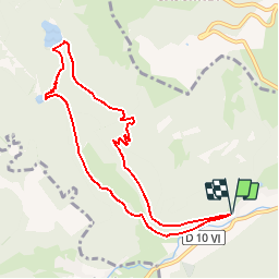
Trail Walking of 8.5 km to be discovered at Grand Est, Haut-Rhin, Metzeral. This trail is proposed by patrickbeyrath.

Description

GR5 rectangle rouge le long de la Fecht jusqu'àu Lac Fischboedle  
ensuite direction Lac Schisrothried et ensuite rectangle rouge blanc rouge vers le Riedwald et tourner à droite pour rejoindre le GR5 rectangle rouge

Elevation profile

Positioning

Country:
France
Region :
Grand Est
Department/Province :
Haut-Rhin
Municipality :
Metzeral
Location:
Unknown
Start:(UTM)
354836 ; 5319365 (32U) N.


Close
My subscriptions