


MMV Val Cenis

prof_physique
User
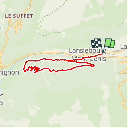

Length
16.1 km

Max alt
1842 m

Uphill gradient
560 m
Km-Effort
24 km

Min alt
1396 m

Downhill gradient
561 m
Boucle
Yes
Creation date :
2014-12-10 00:00:00.0
Updated on :
2014-12-10 00:00:00.0
1h47
Difficulty : Medium

FREE GPS app for hiking
 SityTrail
IGN / Geographical institutes
SityTrail Plus
The world is yours!
About
Trail Mountain bike of 16.1 km to be discovered at Auvergne-Rhône-Alpes, Savoy, Val-Cenis. This trail is proposed by prof_physique.
Positioning
Country:
France
Region :
Auvergne-Rhône-Alpes
Department/Province :
Savoy
Municipality :
Val-Cenis
Location:
Unknown
Start:(Dec)
Start:(UTM)
334237 ; 5016804 (32T) N.
Comments