


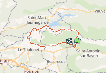
HBR 2112 Court Lacs Bimont Zola, dep le Tholonet

jmheydorff
User

Length
15 km

Max alt
674 m

Uphill gradient
698 m
Km-Effort
24 km

Min alt
228 m

Downhill gradient
698 m
Boucle
Yes
Creation date :
2017-03-22 00:00:00.0
Updated on :
2017-03-22 00:00:00.0
4h59
Difficulty : Medium

FREE GPS app for hiking
 SityTrail
IGN / Geographical institutes
SityTrail Plus
The world is yours!
About
Trail Walking of 15 km to be discovered at Provence-Alpes-Côte d'Azur, Bouches-du-Rhône, Saint-Antonin-sur-Bayon. This trail is proposed by jmheydorff.
Description
Pkg Plan de l'Anchois
Positioning
Country:
France
Region :
Provence-Alpes-Côte d'Azur
Department/Province :
Bouches-du-Rhône
Municipality :
Saint-Antonin-sur-Bayon
Location:
Unknown
Start:(Dec)
Start:(UTM)
707260 ; 4822190 (31T) N.
Comments