Trail Walking Brison-Saint-Innocent - brison st innocent - Photo
© OpenStreetMap contributors
Length
Length
13.2 km
Max alt
Max alt
837 m
Uphill gradient
Uphill gradient
593 m
Km-Effort
Km-Effort  
21 km
Min alt
Min alt
264 m
Downhill gradient
Downhill gradient
593 m
Boucle
Boucle
Yes
Creation date :
2017-03-23 00:00:00.0
Updated on :
2017-03-23 00:00:00.0

(0 Reviews)

Walking
Walking
4h09
Difficulty : Medium

Scan this QR Code to open this trail in the SityTrail application

FREE GPS app for hiking

Logo SityTrail SityTrail

IGN / Geographical institutes

Download SityTrail from the App Store Download SityTrail from Google Play

Logo SityTrail SityTrail World

The world is yours!

Download SityTrail from the App Store Download SityTrail from Google Play Download SityTrail on Huawei AppGallery

About

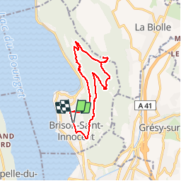
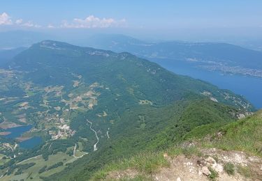
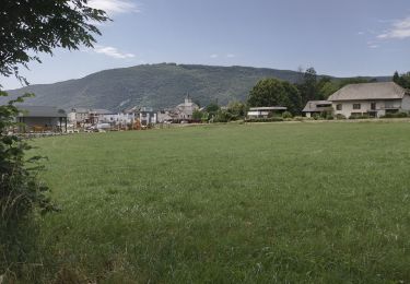
Trail Walking of 13.2 km to be discovered at Auvergne-Rhône-Alpes, Savoy, Brison-Saint-Innocent. This trail is proposed by floup6138.

Description

très belle randonnée avec de beaux points de vue sur le lac du Bourget.
chemins biens entretenus.
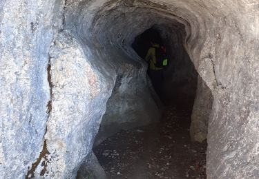
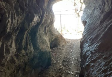
2 difficultés : la grotte des fées et croix de meyrieu à éviter si le chemin est humide.

Elevation profile

Positioning

Country:
France
Region :
Auvergne-Rhône-Alpes
Department/Province :
Savoy
Municipality :
Brison-Saint-Innocent
Location:
Unknown
Start:(UTM)
724799 ; 5067441 (31T) N.

Trails nearby

Trail Walking Brison-Saint-Innocent - La Croix de Meyrieu, retour par la Grotte des Fées, depuis les Combes - Photo
Walking
tracegps

Walking

Easy
(2)
Brison-Saint-Innocent, Auvergne-Rhône-Alpes, Savoy, France
8.5 km | 14.8 km-effort
3h 30min
Yes
Trail Mountain bike Aix-les-Bains - Randolac 2008 - Epine Chat Chambotte - Photo
Mountain bike
tracegps

Mountain bike

Very difficult
(1)
Aix-les-Bains, Auvergne-Rhône-Alpes, Savoy, France
64 km | 94 km-effort
7h 0min
Yes
Trail Electric bike Aix-les-Bains - Aix les bains tour lac de Bourget abbaye Hautecombes  - Photo
Electric bike
GUIDE
antignacs

Electric bike

Medium
Aix-les-Bains, Auvergne-Rhône-Alpes, Savoy, France
66 km | 85 km-effort
5h 8min
Yes
Trail Walking Saint-Jean-de-Chevelu - La dent du chat - Photo
Walking
tippex01

Walking

Difficult
(1)
Saint-Jean-de-Chevelu, Auvergne-Rhône-Alpes, Savoy, France
3.1 km | 9.8 km-effort
1h 30min
No
Trail Via ferrata La Chapelle-du-Mont-du-Chat - 2011-04-03 via ferrata Col du chat - Photo
Via ferrata
phschaefer

Via ferrata

Easy
(1)
La Chapelle-du-Mont-du-Chat, Auvergne-Rhône-Alpes, Savoy, France
3.6 km | 6.8 km-effort
Unknown
No
Trail Walking La Chapelle-du-Mont-du-Chat - 270523 Tour et Dent du Chat - Photo
Walking
mzonzon05

Walking

Easy
La Chapelle-du-Mont-du-Chat, Auvergne-Rhône-Alpes, Savoy, France
10 km | 21 km-effort
4h 15min
Yes
Trail Walking Brison-Saint-Innocent - GROTTE AUX FEES-G2-19-09-22 - Photo
Walking
papou73

Walking

Medium
Brison-Saint-Innocent, Auvergne-Rhône-Alpes, Savoy, France
5.6 km | 9.5 km-effort
2h 8min
Yes
Trail Walking Brison-Saint-Innocent - GROTTE AUX FEES-G1-19-09-22 - Photo
Walking
papou73

Walking

Difficult
Brison-Saint-Innocent, Auvergne-Rhône-Alpes, Savoy, France
7.7 km | 12.5 km-effort
2h 50min
Yes
Trail Walking La Biolle - La Biolle  - Photo
Walking
roclem421

Walking

Difficult
La Biolle, Auvergne-Rhône-Alpes, Savoy, France
12 km | 15.1 km-effort
4h 20min
Yes


Close
My subscriptions