tour du lac de Matemale

Axelloceane
User
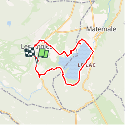

Length
14.4 km

Max alt
1700 m

Uphill gradient
244 m
Km-Effort
17.6 km

Min alt
1530 m

Downhill gradient
248 m
Boucle
Yes
Creation date :
2014-12-10 00:00:00.0
Updated on :
2014-12-10 00:00:00.0
3h51
Difficulty : Easy

FREE GPS app for hiking
 SityTrail
IGN / Geographical institutes
SityTrail Plus
The world is yours!
About
Trail Walking of 14.4 km to be discovered at Occitania, Pyrénées-Orientales, Les Angles. This trail is proposed by Axelloceane.
Positioning
Country:
France
Region :
Occitania
Department/Province :
Pyrénées-Orientales
Municipality :
Les Angles
Location:
Unknown
Start:(Dec)
Start:(UTM)
423905 ; 4713295 (31T) N.
Comments