Trail Walking Brouilla - RP66 BROUILLA - BANYULS DELS ASPRES - par les bords de Tech et Vignobles - le 31.03.2017 - Photo

RP66 BROUILLA - BANYULS DELS ASPRES - par les bords de Tech et Vignobles - le 31.03.2017

 jeff66
jeff66

User

© OpenStreetMap contributors
Length
Length
7.5 km
Max alt
Max alt
86 m
Uphill gradient
Uphill gradient
63 m
Km-Effort
Km-Effort  
8.3 km
Min alt
Min alt
35 m
Downhill gradient
Downhill gradient
63 m
Boucle
Boucle
Yes
Creation date :
2017-03-31 00:00:00.0
Updated on :
2017-03-31 00:00:00.0

(3 Reviews)

Walking
Walking
1h26
Difficulty : Easy

Scan this QR Code to open this trail in the SityTrail application

FREE GPS app for hiking

Logo SityTrail SityTrail

IGN / Geographical institutes

Download SityTrail from the App Store Download SityTrail from Google Play

Logo SityTrail SityTrail World

The world is yours!

Download SityTrail from the App Store Download SityTrail from Google Play Download SityTrail on Huawei AppGallery

About

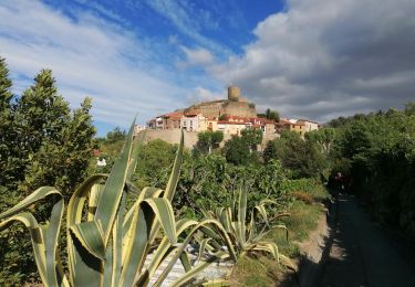
Trail Walking of 7.5 km to be discovered at Occitania, Pyrénées-Orientales, Brouilla. This trail is proposed by jeff66.

Description

RP66 BROUILLA - BANYULS DELS ASPRES - par les bords de Tech et Vignobles - le 31.03.2017

Elevation profile

Positioning

Country:
France
Region :
Occitania
Department/Province :
Pyrénées-Orientales
Municipality :
Brouilla
Location:
Unknown
Start:(UTM)
491939 ; 4712203 (31T) N.

Comments

Please log in to post a review or rate the element


Joli randonnée, au bord du Tech, au milieu des vergers , quelques passages sur la route …


Facile, petits chemins sympas, et vue magnifique sur les Alberes !


Très facile


Trails nearby

Trail Walking Laroque-des-Albères - 66 LAROQUE DES ALBERES (maison) SOREDE, par pistes DFCI AL12 et 19, mas del Ca et mas Manere, Itin.16  - Photo
Walking
jeff66

Walking

Medium
(1)
Laroque-des-Albères, Occitania, Pyrénées-Orientales, France
11.2 km | 15.3 km-effort
2h 5min
Yes
Trail Walking Laroque-des-Albères - 66 SOREDE, LAROQUE DES ALBERES, chemins des Mas - Photo
Walking
jeff66

Walking

Medium
(1)
Laroque-des-Albères, Occitania, Pyrénées-Orientales, France
7 km | 8.9 km-effort
1h 22min
Yes
Trail Walking Montesquieu-des-Albères - MONTESQUIEU-DES-ALBERES 66 - Les Agouillous - les chemins de l'eau dans les Albères - Photo
Walking
jeff66

Walking

Medium
(1)
Montesquieu-des-Albères, Occitania, Pyrénées-Orientales, France
12.7 km | 13.9 km-effort
2h 16min
Yes
Trail Walking Palau-del-Vidre - PALAU-DEL-VIDRE 66 - Boucle de Villeclare - promenade dans les vergers et cultures maraîchères  - Photo
Walking
jeff66

Walking

Easy
(2)
Palau-del-Vidre, Occitania, Pyrénées-Orientales, France
7.5 km | 7.9 km-effort
1h 16min
Yes
Trail Walking Saint-Jean-Lasseille - ST-JEAN-LASSEILLE 66 - terroirs des Aspres - Photo
Walking
jeff66

Walking

Easy
(1)
Saint-Jean-Lasseille, Occitania, Pyrénées-Orientales, France
12.2 km | 14.3 km-effort
2h 6min
Yes
Trail Walking Sorède - RP66 SOREDE - ND du château - la vallée heureuse  - Photo
Walking
jeff66

Walking

Medium
(1)
Sorède, Occitania, Pyrénées-Orientales, France
10.2 km | 14.9 km-effort
1h 48min
Yes
Trail Walking Laroque-des-Albères - LAROQUE des A. 66 - Le puits à neige - Casot del Guarda - Photo
Walking
jeff66

Walking

Medium
(2)
Laroque-des-Albères, Occitania, Pyrénées-Orientales, France
12.3 km | 19 km-effort
2h 17min
Yes
Trail Walking Laroque-des-Albères - LAROQUE boucle village - Photo
Walking
jeff66

Walking

Very easy
(2)
Laroque-des-Albères, Occitania, Pyrénées-Orientales, France
5.2 km | 6.1 km-effort
53min
Yes
Trail Walking Laroque-des-Albères - La Roque des Alberes, randonnée et botanique - Photo
Walking
nandaf

Walking

Laroque-des-Albères, Occitania, Pyrénées-Orientales, France
6.1 km | 9 km-effort
2h 29min
Yes


Close
My subscriptions