


RP66 COLLIOURE - com de mollo - la galera - le 10.04.2017

jeff66
User
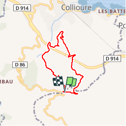

Length
6.2 km

Max alt
257 m

Uphill gradient
235 m
Km-Effort
9.4 km

Min alt
36 m

Downhill gradient
239 m
Boucle
Yes
Creation date :
2017-04-11 00:00:00.0
Updated on :
2017-04-11 00:00:00.0
1h36
Difficulty : Medium

FREE GPS app for hiking
 SityTrail
IGN / Geographical institutes
SityTrail Plus
The world is yours!
About
Trail Walking of 6.2 km to be discovered at Occitania, Pyrénées-Orientales, Collioure. This trail is proposed by jeff66.
Description
RP66 COLLIOURE - com de mollo - la galera - le 10.04.2017
Positioning
Country:
France
Region :
Occitania
Department/Province :
Pyrénées-Orientales
Municipality :
Collioure
Location:
Unknown
Start:(Dec)
Start:(UTM)
506491 ; 4705630 (31T) N.
Comments