Trail Walking Cases-de-Pène - RP66 CASES DE PÊNE - tour del far - Photo

RP66 CASES DE PÊNE - tour del far

 jeff66
jeff66

User

© OpenStreetMap contributors
Length
Length
8.7 km
Max alt
Max alt
481 m
Uphill gradient
Uphill gradient
438 m
Km-Effort
Km-Effort  
14.5 km
Min alt
Min alt
51 m
Downhill gradient
Downhill gradient
438 m
Boucle
Boucle
Yes
Creation date :
2017-04-11 00:00:00.0
Updated on :
2017-04-11 00:00:00.0

(0 Reviews)

Walking
Walking
2h17
Difficulty : Medium

Scan this QR Code to open this trail in the SityTrail application

FREE GPS app for hiking

Logo SityTrail SityTrail

IGN / Geographical institutes

Download SityTrail from the App Store Download SityTrail from Google Play

Logo SityTrail SityTrail Plus

The world is yours!

Download SityTrail from the App Store Download SityTrail from Google Play Download SityTrail on Huawei AppGallery

About

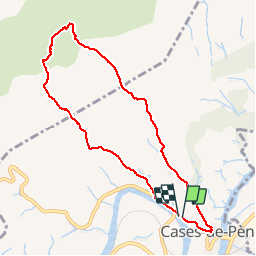
Trail Walking of 8.7 km to be discovered at Occitania, Pyrénées-Orientales, Cases-de-Pène. This trail is proposed by jeff66.

Description

RP66 CASES DE PÊNE - route de Tautavel - piste DFCI C17 - ravin de Badeilla - le camp gras - Collada D'en Gilbert - Serrat de Trenque Bouteils - tour del far - coma d'en Finestre - jasse d'en Dosset - coume d'en Roc - RD59 - le 11.04.2017

Elevation profile

Positioning

Country:
France
Region :
Occitania
Department/Province :
Pyrénées-Orientales
Municipality :
Cases-de-Pène
Location:
Unknown
Start:(UTM)
482093 ; 4736560 (31T) N.


Close
My subscriptions