


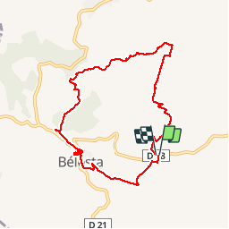
RP66 BELESTA - Ravin de l'Orteill - Dolmen - piste DFCI F135 - chapelle Saint Barthélémy - pic Aubeill

jeff66
User


2h03
Difficulty : Medium

FREE GPS app for hiking
 SityTrail
IGN / Geographical institutes
SityTrail Plus
The world is yours!
About
Trail Walking of 9.2 km to be discovered at Occitania, Pyrénées-Orientales, Bélesta. This trail is proposed by jeff66.
Description
RP66 BELESTA - parking à proximité ponts et RD38 - Ravin de l'Orteill - BELESTA - église - Ruelles - cave Coop - Dolmen - piste DFCI F135 - chapelle Saint Barthélémy - pic Aubeill - les roques planes - piste DFCI F135 - le 14.04.2017
Positioning
Comments