


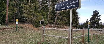
Col de la Llose - Borne 2042

Roulland
User

Length
10.7 km

Max alt
2034 m

Uphill gradient
244 m
Km-Effort
13.9 km

Min alt
1862 m

Downhill gradient
244 m
Boucle
Yes
Creation date :
2017-04-15 00:00:00.0
Updated on :
2017-04-15 00:00:00.0
2h50
Difficulty : Easy

FREE GPS app for hiking
 SityTrail
IGN / Geographical institutes
SityTrail Plus
The world is yours!
About
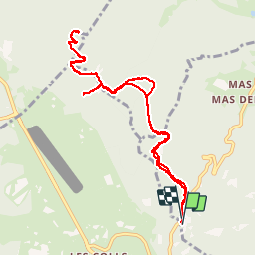
Trail Walking of 10.7 km to be discovered at Occitania, Pyrénées-Orientales, Ayguatébia-Talau. This trail is proposed by Roulland.
Photos


Positioning
Country:
France
Region :
Occitania
Department/Province :
Pyrénées-Orientales
Municipality :
Ayguatébia-Talau
Location:
Unknown
Start:(Dec)
Start:(UTM)
429550 ; 4709566 (31T) N.
Comments