


carla, labat, descente marie (Vincent)

mapomme
User

Length
10.1 km

Max alt
182 m

Uphill gradient
263 m
Km-Effort
13.6 km

Min alt
64 m

Downhill gradient
263 m
Boucle
Yes
Creation date :
2017-04-18 00:00:00.0
Updated on :
2017-04-18 00:00:00.0
1h10
Difficulty : Easy

FREE GPS app for hiking
 SityTrail
IGN / Geographical institutes
SityTrail Plus
The world is yours!
About
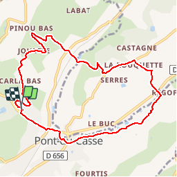
Trail Mountain bike of 10.1 km to be discovered at New Aquitaine, Lot-et-Garonne, Pont-du-Casse. This trail is proposed by mapomme.
Description
Par le haut (Carla) puis moulin labat puis descente marie et final par bois et dîner spectacle
Positioning
Country:
France
Region :
New Aquitaine
Department/Province :
Lot-et-Garonne
Municipality :
Pont-du-Casse
Location:
Unknown
Start:(Dec)
Start:(UTM)
313954 ; 4900986 (31T) N.
Comments