


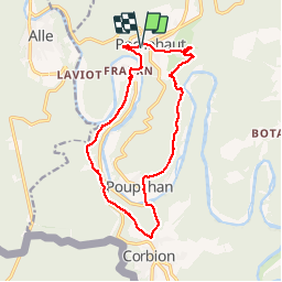
ROCHEHAUT (Crêtes & Echelles)

GerardBouche
User

Length
13.8 km

Max alt
376 m

Uphill gradient
532 m
Km-Effort
21 km

Min alt
194 m

Downhill gradient
525 m
Boucle
Yes
Creation date :
2017-04-28 00:00:00.0
Updated on :
2017-04-28 00:00:00.0
3h24
Difficulty : Medium

FREE GPS app for hiking
 SityTrail
IGN / Geographical institutes
SityTrail Plus
The world is yours!
About
Trail Walking of 13.8 km to be discovered at Wallonia, Luxembourg, Bouillon. This trail is proposed by GerardBouche.
Description
Très beau parcours plutôt physique par les "Crêtes de Frahan" et le village de Poupehan. La deuxième partie,avec bon dénivelé, par les échelles des Faloises.
Photos
 - Photo 1")
 - Photo 2")
Positioning
Country:
Belgium
Region :
Wallonia
Department/Province :
Luxembourg
Municipality :
Bouillon
Location:
Rochehaut
Start:(Dec)
Start:(UTM)
644098 ; 5522744 (31U) N.
Comments