


Montboyer 16

bert16
User
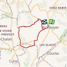

Length
10.9 km

Max alt
150 m

Uphill gradient
211 m
Km-Effort
13.7 km

Min alt
55 m

Downhill gradient
209 m
Boucle
Yes
Creation date :
2017-05-01 00:00:00.0
Updated on :
2017-05-01 00:00:00.0
2h59
Difficulty : Easy

FREE GPS app for hiking
 SityTrail
IGN / Geographical institutes
SityTrail Plus
The world is yours!
About
Trail Walking of 10.9 km to be discovered at New Aquitaine, Charente, Montboyer. This trail is proposed by bert16.
Description
Randonnée pédestre organisée par les aAmis & Anciens Elèves de Brie-Sous-Chalais 16210
Positioning
Country:
France
Region :
New Aquitaine
Department/Province :
Charente
Municipality :
Montboyer
Location:
Unknown
Start:(Dec)
Start:(UTM)
270594 ; 5023256 (31T) N.
Comments