


TDP N°1 HENDAYE OLHETTE

jeff2
User
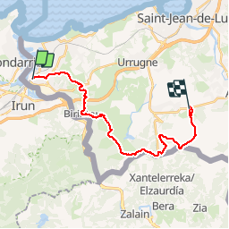

Length
24 km

Max alt
530 m

Uphill gradient
1078 m
Km-Effort
38 km

Min alt
19 m

Downhill gradient
1027 m
Boucle
No
Creation date :
2017-05-05 00:00:00.0
Updated on :
2017-05-05 00:00:00.0
7h15
Difficulty : Unknown

FREE GPS app for hiking
 SityTrail
IGN / Geographical institutes
SityTrail Plus
The world is yours!
About
Trail Other activity of 24 km to be discovered at New Aquitaine, Pyrénées-Atlantiques, Hendaye. This trail is proposed by jeff2.
Description
Sympatoche
Photos


Positioning
Country:
France
Region :
New Aquitaine
Department/Province :
Pyrénées-Atlantiques
Municipality :
Hendaye
Location:
Unknown
Start:(Dec)
Start:(UTM)
598759 ; 4800674 (30T) N.
Comments