


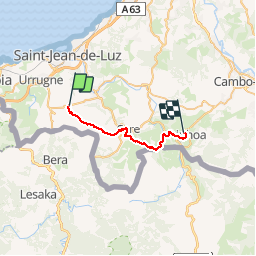
TDP N°2 OLHETTE AÏNHOA

jeff2
User

Length
23 km

Max alt
562 m

Uphill gradient
793 m
Km-Effort
33 km

Min alt
47 m

Downhill gradient
746 m
Boucle
No
Creation date :
2017-05-05 00:00:00.0
Updated on :
2017-05-05 00:00:00.0
6h10
Difficulty : Unknown

FREE GPS app for hiking
 SityTrail
IGN / Geographical institutes
SityTrail Plus
The world is yours!
About
Trail Other activity of 23 km to be discovered at New Aquitaine, Pyrénées-Atlantiques, Urrugne. This trail is proposed by jeff2.
Description
Fastoche
Photos


Positioning
Country:
France
Region :
New Aquitaine
Department/Province :
Pyrénées-Atlantiques
Municipality :
Urrugne
Location:
Unknown
Start:(Dec)
Start:(UTM)
608600 ; 4798998 (30T) N.
Comments