


TDP N°5 ST ÉTIENNE DE BAIGORRY ST JEAN PIEDS DE PORT

jeff2
User
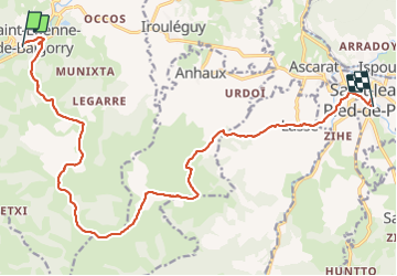

Length
19.6 km

Max alt
1015 m

Uphill gradient
1001 m
Km-Effort
33 km

Min alt
155 m

Downhill gradient
992 m
Boucle
No
Creation date :
2017-05-07 00:00:00.0
Updated on :
2017-05-07 00:00:00.0
7h07
Difficulty : Unknown

FREE GPS app for hiking
 SityTrail
IGN / Geographical institutes
SityTrail Plus
The world is yours!
About
Trail Other activity of 19.6 km to be discovered at New Aquitaine, Pyrénées-Atlantiques, Saint-Étienne-de-Baïgorry. This trail is proposed by jeff2.
Description
Fastoche
Photos


Positioning
Country:
France
Region :
New Aquitaine
Department/Province :
Pyrénées-Atlantiques
Municipality :
Saint-Étienne-de-Baïgorry
Location:
Unknown
Start:(Dec)
Start:(UTM)
634369 ; 4781612 (30T) N.
Comments