


cerbere

Phidel66
User

Length
10.8 km

Max alt
304 m

Uphill gradient
437 m
Km-Effort
16.6 km

Min alt
2 m

Downhill gradient
436 m
Boucle
Yes
Creation date :
2016-01-19 00:00:00.0
Updated on :
2016-01-19 00:00:00.0
3h39
Difficulty : Medium

FREE GPS app for hiking
 SityTrail
IGN / Geographical institutes
SityTrail Plus
The world is yours!
About
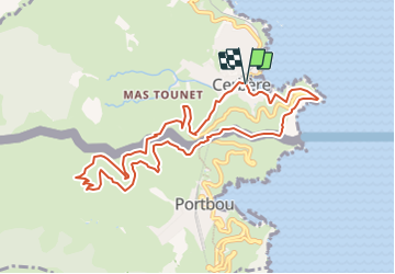
Trail Walking of 10.8 km to be discovered at Occitania, Pyrénées-Orientales, Cerbère. This trail is proposed by Phidel66.
Positioning
Country:
France
Region :
Occitania
Department/Province :
Pyrénées-Orientales
Municipality :
Cerbère
Location:
Unknown
Start:(Dec)
Start:(UTM)
513614 ; 4698797 (31T) N.
Comments