


Bouillouses - Etang PRADELLA - etang Noir

ARPF
User
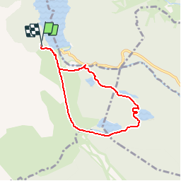

Length
6.8 km

Max alt
2048 m

Uphill gradient
187 m
Km-Effort
9.3 km

Min alt
1944 m

Downhill gradient
190 m
Boucle
Yes
Creation date :
2017-05-13 00:00:00.0
Updated on :
2017-05-13 00:00:00.0
5m
Difficulty : Medium

FREE GPS app for hiking
 SityTrail
IGN / Geographical institutes
SityTrail Plus
The world is yours!
About
Trail Walking of 6.8 km to be discovered at Occitania, Pyrénées-Orientales, Angoustrine-Villeneuve-des-Escaldes. This trail is proposed by ARPF.
Description
J3 P2 T2
Bouillouses - Etang PRADELLA - etang Noir
-Dessin approximatif_
Positioning
Country:
France
Region :
Occitania
Department/Province :
Pyrénées-Orientales
Municipality :
Angoustrine-Villeneuve-des-Escaldes
Location:
Unknown
Start:(Dec)
Start:(UTM)
417623 ; 4712505 (31T) N.
Comments