


Bouillouses - PIC DES MORTIERS - pierres ecrites

ARPF
User
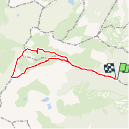

Length
14.5 km

Max alt
2591 m

Uphill gradient
1011 m
Km-Effort
28 km

Min alt
1629 m

Downhill gradient
1014 m
Boucle
Yes
Creation date :
2017-05-13 00:00:00.0
Updated on :
2017-05-13 00:00:00.0
5m
Difficulty : Very difficult

FREE GPS app for hiking
 SityTrail
IGN / Geographical institutes
SityTrail Plus
The world is yours!
About
Trail Walking of 14.5 km to be discovered at Occitania, Pyrénées-Orientales, Fontrabiouse. This trail is proposed by ARPF.
Description
J3 P3 T3
-Dessin approximatif-
Positioning
Country:
France
Region :
Occitania
Department/Province :
Pyrénées-Orientales
Municipality :
Fontrabiouse
Location:
Unknown
Start:(Dec)
Start:(UTM)
422625 ; 4720741 (31T) N.
Comments