Trail Walking Miazzina - Italie, Le Monte Todun - Photo

Italie, Le Monte Todun

 zanogueb
zanogueb

User

© OpenStreetMap contributors
Length
Length
12.8 km
Max alt
Max alt
1286 m
Uphill gradient
Uphill gradient
726 m
Km-Effort
Km-Effort  
23 km
Min alt
Min alt
669 m
Downhill gradient
Downhill gradient
729 m
Boucle
Boucle
Yes
Creation date :
2017-05-29 00:00:00.0
Updated on :
2020-06-03 16:45:37.927

(0 Reviews)

Walking
Walking
4h53
Difficulty : Difficult

Scan this QR Code to open this trail in the SityTrail application

FREE GPS app for hiking

Logo SityTrail SityTrail

IGN / Geographical institutes

Download SityTrail from the App Store Download SityTrail from Google Play

Logo SityTrail SityTrail World

The world is yours!

Download SityTrail from the App Store Download SityTrail from Google Play Download SityTrail on Huawei AppGallery

About

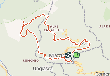
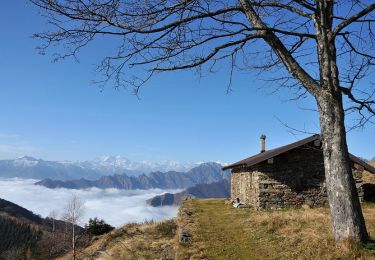
Trail Walking of 12.8 km to be discovered at Piemont, Verbano-Cusio-Ossola, Miazzina. This trail is proposed by zanogueb.

Description

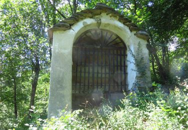
Départ vers Miazzina. La randonnée permet de découvrir la nature sauvage qui annonce l'entrée dans le Parc National de Val Grande que l'on aperçoit du sommet du Monte Todun. Le parcours se poursuit dans l'arrière-pays de Verbania, avec vues sur le Lac Majeur. Balcon sur le très vaste Parc National de 15000 hectares. Puis, retour vers la Chapelle Fina par un bois et arrivée à Miazzina.

Elevation profile

Positioning

Country:
Italy
Region :
Piemont
Department/Province :
Verbano-Cusio-Ossola
Municipality :
Miazzina
Location:
Unknown
Start:(UTM)
463610 ; 5091248 (32T) N.

Trails nearby

Trail On foot Aurano - R15 Aurano - Calpera - il Colle - Photo
On foot
PRO

On foot

Easy
Aurano, Piemont, Verbano-Cusio-Ossola, Italy
5.7 km | 11.2 km-effort
2h 32min
No
Trail On foot Aurano - R13 Scareno - Pian d'Arla - Photo
On foot
PRO

On foot

Easy
Aurano, Piemont, Verbano-Cusio-Ossola, Italy
3.5 km | 10 km-effort
2h 16min
No
Trail On foot Aurano - R11 Scareno - Alpe Piaggia - Passo Folungo - Photo
On foot
PRO

On foot

Easy
Aurano, Piemont, Verbano-Cusio-Ossola, Italy
5.9 km | 14 km-effort
3h 10min
No
Trail On foot Aurano - R08 Aurano - Esio - Premeno - Photo
On foot
PRO

On foot

Easy
Aurano, Piemont, Verbano-Cusio-Ossola, Italy
4.8 km | 9.3 km-effort
2h 7min
No
Trail On foot Miazzina - R03a Cappella Fina bivio R03 - Bivio R05 tra Cappella Porta e Cornala - Photo
On foot
PRO

On foot

Easy
Miazzina, Piemont, Verbano-Cusio-Ossola, Italy
4.4 km | 6.4 km-effort
1h 27min
No
Trail On foot Caprezzo - R05 Caprezzo - Pian Cavallone bivio R07 - Photo
On foot
PRO

On foot

Easy
Caprezzo, Piemont, Verbano-Cusio-Ossola, Italy
6.6 km | 16.3 km-effort
3h 42min
No
Trail On foot Intragna - R07 Intragna - Cappella del Pian Cavallone - Photo
On foot
PRO

On foot

Easy
Intragna, Piemont, Verbano-Cusio-Ossola, Italy
4.9 km | 13.2 km-effort
2h 59min
No
Trail On foot Cambiasca - R03 Cambiasca - Pian Cavallone - Pizzo Marona - Monte Zeda - Photo
On foot
PRO

On foot

Difficult
Cambiasca, Piemont, Verbano-Cusio-Ossola, Italy
16.1 km | 36 km-effort
8h 14min
No
Trail On foot Aurano - R14 Aurano - Luera - Photo
On foot
PRO

On foot

Easy
Aurano, Piemont, Verbano-Cusio-Ossola, Italy
4.3 km | 6.3 km-effort
1h 25min
No


Close
My subscriptions