Trail Walking Autigny-la-Tour - Autigny la tour  - Photo
© OpenStreetMap contributors
Length
Length
15.4 km
Max alt
Max alt
393 m
Uphill gradient
Uphill gradient
248 m
Km-Effort
Km-Effort  
18.7 km
Min alt
Min alt
284 m
Downhill gradient
Downhill gradient
248 m
Boucle
Boucle
Yes
Creation date :
2017-06-03 00:00:00.0
Updated on :
2017-06-03 00:00:00.0

(0 Reviews)

Walking
Walking
3h34
Difficulty : Easy

Scan this QR Code to open this trail in the SityTrail application

FREE GPS app for hiking

Logo SityTrail SityTrail

IGN / Geographical institutes

Download SityTrail from the App Store Download SityTrail from Google Play

Logo SityTrail SityTrail World

The world is yours!

Download SityTrail from the App Store Download SityTrail from Google Play Download SityTrail on Huawei AppGallery

About

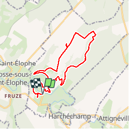
Trail Walking of 15.4 km to be discovered at Grand Est, Vosges, Autigny-la-Tour. This trail is proposed by grattounette.

Description

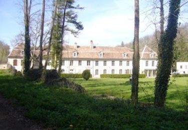
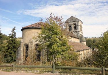
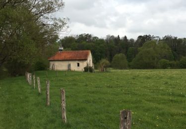
départ du pont d'autigny passage par son église, direction le moulin du bas les vignes, et descendre vers le moulin du haut remonter par un long chemin blanc le bois de boinville, le cul des cerises puis retour par petite route de Martigny les gerbonvaux, sur le chemin faire une halte à la fontaine Amont, superbe point de vue sur autigny depuis le coteaux de la rivière retour par le petit bois du haut de fruze, petit détour par un superbe calvaire bien caché retour au point de de départ avec vue sur le beau pont de Autigny la tour

Elevation profile

Positioning

Country:
France
Region :
Grand Est
Department/Province :
Vosges
Municipality :
Autigny-la-Tour
Location:
Unknown
Start:(UTM)
704199 ; 5364116 (31U) N.

Trails nearby

Trail Walking Rollainville - A la découverte de la forêt de Neufeys - Photo
Walking
mannequ1

Walking

Very easy
(1)
Rollainville, Grand Est, Vosges, France
14.7 km | 18.3 km-effort
3h 27min
Yes
Trail On foot Rollainville - Sentier de la Frézelle - Photo
On foot
PRO

On foot

Easy
Rollainville, Grand Est, Vosges, France
10.5 km | 12.7 km-effort
2h 53min
Yes
Trail Walking Soulosse-sous-Saint-Élophe - Saint Elophe et Brancourt - Photo
Walking
Samuel88300

Walking

Very easy
Soulosse-sous-Saint-Élophe, Grand Est, Vosges, France
4.1 km | 5 km-effort
1h 3min
Yes
Trail Walking Rollainville - circuit  - Photo
Walking
CDSM 55

Walking

Medium
Rollainville, Grand Est, Vosges, France
7.9 km | 9.7 km-effort
1h 41min
Yes
Trail Walking Neufchâteau - sentiers de la pelouse calcaire et de Neufeys - Photo
Walking
Samuel88300

Walking

Easy
Neufchâteau, Grand Est, Vosges, France
22 km | 27 km-effort
7h 42min
Yes
Trail Walking Neufchâteau - La grotte de l'Enfer (Neufchâteau) - Photo
Walking
tracegps

Walking

Medium
(1)
Neufchâteau, Grand Est, Vosges, France
11.6 km | 13.8 km-effort
3h 0min
Yes
Trail Hybrid bike Neufchâteau - neufchateau  - Photo
Hybrid bike
famiski

Hybrid bike

Very easy
Neufchâteau, Grand Est, Vosges, France
41 km | 46 km-effort
3h 50min
No
Trail Walking Harchéchamp - harchechamp  - Photo
Walking
lamiche88

Walking

Easy
Harchéchamp, Grand Est, Vosges, France
12.7 km | 16.3 km-effort
3h 20min
Yes
Trail Walking Neufchâteau - neufchateau 15km - Photo
Walking
lamiche88

Walking

Easy
Neufchâteau, Grand Est, Vosges, France
14.9 km | 18.4 km-effort
3h 14min
No


Close
My subscriptions