


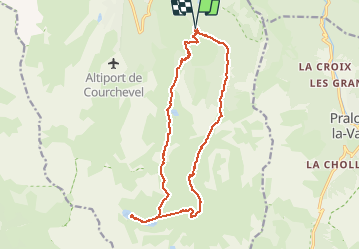
lacs Merlet 18 km départ Courchevel 1650 Pralin retour par la crête ouest.

redfire73
User


5h59
Difficulty : Easy

FREE GPS app for hiking
 SityTrail
IGN / Geographical institutes
SityTrail Plus
The world is yours!
About
Trail Walking of 18 km to be discovered at Auvergne-Rhône-Alpes, Savoy, Courchevel. This trail is proposed by redfire73.
Description
Très beaux lacs glaciaires, deux refuges proches. Vue éblouissante sur le retour mais passage par les pistes avant la descente vers le point de départ. Difficulté moyenne. Possibilité de faire un stop à un refuge puis faite le petit Mont Blanc.
Positioning
Comments