


F73470_Novalaise_le_Signal_ST_CG

ageo
User
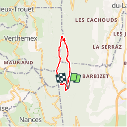

Length
8.6 km

Max alt
1467 m

Uphill gradient
400 m
Km-Effort
13.9 km

Min alt
1091 m

Downhill gradient
395 m
Boucle
Yes
Creation date :
2017-06-25 00:00:00.0
Updated on :
2017-06-25 00:00:00.0
3h02
Difficulty : Easy

FREE GPS app for hiking
 SityTrail
IGN / Geographical institutes
SityTrail Plus
The world is yours!
About
Trail Walking of 8.6 km to be discovered at Auvergne-Rhône-Alpes, Savoy, La Motte-Servolex. This trail is proposed by ageo.
Photos


Positioning
Country:
France
Region :
Auvergne-Rhône-Alpes
Department/Province :
Savoy
Municipality :
La Motte-Servolex
Location:
Unknown
Start:(Dec)
Start:(UTM)
720126 ; 5053964 (31T) N.
Comments