


V66 - SOREDE - ARGELES - ST.ANDRE - ST.GENIS - LAROQUE - le 22.06.2017

jeff66
User
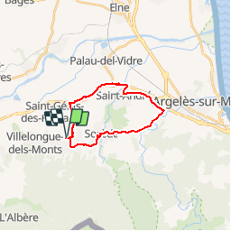

Length
18.9 km

Max alt
106 m

Uphill gradient
151 m
Km-Effort
21 km

Min alt
22 m

Downhill gradient
152 m
Boucle
Yes
Creation date :
2017-06-23 00:00:00.0
Updated on :
2017-06-23 00:00:00.0
53m
Difficulty : Easy

FREE GPS app for hiking
 SityTrail
IGN / Geographical institutes
SityTrail Plus
The world is yours!
About
Trail Cycle of 18.9 km to be discovered at Occitania, Pyrénées-Orientales, Laroque-des-Albères. This trail is proposed by jeff66.
Description
V66 - SOREDE - ARGELES - ST.ANDRE - ST.GENIS - LAROQUE - le 22.06.2017
Positioning
Country:
France
Region :
Occitania
Department/Province :
Pyrénées-Orientales
Municipality :
Laroque-des-Albères
Location:
Unknown
Start:(Dec)
Start:(UTM)
494303 ; 4708444 (31T) N.
Comments