


Totom 4 lacs

dinozore
User
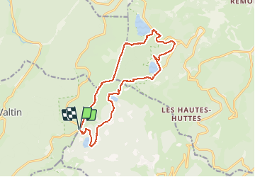

Length
15.6 km

Max alt
1304 m

Uphill gradient
783 m
Km-Effort
26 km

Min alt
950 m

Downhill gradient
782 m
Boucle
Yes
Creation date :
2017-07-13 00:00:00.0
Updated on :
2017-07-13 00:00:00.0
4h37
Difficulty : Medium

FREE GPS app for hiking
 SityTrail
IGN / Geographical institutes
SityTrail Plus
The world is yours!
About
Trail Other activity of 15.6 km to be discovered at Grand Est, Haut-Rhin, Soultzeren. This trail is proposed by dinozore.
Description
Tour des 4 lacs par le bas et retour par les chaumes
Photos


Positioning
Country:
France
Region :
Grand Est
Department/Province :
Haut-Rhin
Municipality :
Soultzeren
Location:
Unknown
Start:(Dec)
Start:(UTM)
355601 ; 5328434 (32U) N.
Comments
Une rando incontournable avec une vue méritée .