


col d'Ibardin circuit lac

Orage
User
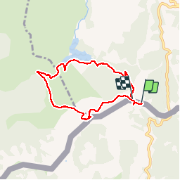

Length
6.7 km

Max alt
562 m

Uphill gradient
369 m
Km-Effort
11.5 km

Min alt
260 m

Downhill gradient
334 m
Boucle
Yes
Creation date :
2017-07-29 00:00:00.0
Updated on :
2017-07-29 00:00:00.0
2h29
Difficulty : Easy

FREE GPS app for hiking
 SityTrail
IGN / Geographical institutes
SityTrail Plus
The world is yours!
About
Trail Walking of 6.7 km to be discovered at New Aquitaine, Pyrénées-Atlantiques, Urrugne. This trail is proposed by Orage.
Positioning
Country:
France
Region :
New Aquitaine
Department/Province :
Pyrénées-Atlantiques
Municipality :
Urrugne
Location:
Unknown
Start:(Dec)
Start:(UTM)
606125 ; 4796270 (30T) N.
Comments