RP66 VILLERACH - col del Forn - la terme - roc dels Moros - roc de la Collada - chapelle ST étienne - le 03.08.2017

jeff66
User
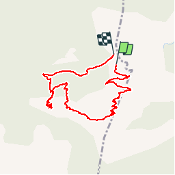

Length
4.5 km

Max alt
988 m

Uphill gradient
301 m
Km-Effort
8.7 km

Min alt
689 m

Downhill gradient
345 m
Boucle
Yes
Creation date :
2017-08-03 00:00:00.0
Updated on :
2017-08-03 00:00:00.0
1h35
Difficulty : Medium

FREE GPS app for hiking
 SityTrail
IGN / Geographical institutes
SityTrail Plus
The world is yours!
About
Trail Walking of 4.5 km to be discovered at Occitania, Pyrénées-Orientales, Clara-Villerach. This trail is proposed by jeff66.
Description
RP66 VILLERACH - col del Forn - la terme - roc dels Moros - roc de la Collada - chapelle ST étienne - le 03.08.2017
Positioning
Country:
France
Region :
Occitania
Department/Province :
Pyrénées-Orientales
Municipality :
Clara-Villerach
Location:
Unknown
Start:(Dec)
Start:(UTM)
455946 ; 4714711 (31T) N.
Comments