Trail Walking Font-Romeu-Odeillo-Via - Coll del Pam lac des  Bouillouses - Photo
 jcmartin
jcmartin

User

© OpenStreetMap contributors
Length
Length
13.3 km
Max alt
Max alt
2048 m
Uphill gradient
Uphill gradient
447 m
Km-Effort
Km-Effort  
19.3 km
Min alt
Min alt
1892 m
Downhill gradient
Downhill gradient
447 m
Boucle
Boucle
Yes
Creation date :
2017-08-03 00:00:00.0
Updated on :
2017-08-03 00:00:00.0

(2 Reviews)

Walking
Walking
4h10
Difficulty : Medium

Scan this QR Code to open this trail in the SityTrail application

FREE GPS app for hiking

Logo SityTrail SityTrail

IGN / Geographical institutes

Download SityTrail from the App Store Download SityTrail from Google Play

Logo SityTrail SityTrail World

The world is yours!

Download SityTrail from the App Store Download SityTrail from Google Play Download SityTrail on Huawei AppGallery

About

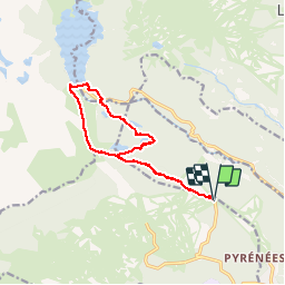
Trail Walking of 13.3 km to be discovered at Occitania, Pyrénées-Orientales, Font-Romeu-Odeillo-Via. This trail is proposed by jcmartin.

Description

Beau parcours mais attention entre l'Estany Llarg et l'Estany Negre le Gps était éteint mais le sentier est bien balisé en jaune, aucun risque de s'égarer, ensuite en arrivant à l'Estany Negre le contournement par le côté nord est un peu acrobatique mieux vaut suivre le sentier bien balisé en jaune par le côté ouest si vous n'aimez pas escalader des rochers et des arbres morts

Elevation profile

Photos

Positioning

Country:
France
Region :
Occitania
Department/Province :
Pyrénées-Orientales
Municipality :
Font-Romeu-Odeillo-Via
Location:
Unknown
Start:(UTM)
421352 ; 4709529 (31T) N.

Comments

Please log in to post a review or rate the element


Trails nearby

Trail Snowshoes Font-Romeu-Odeillo-Via - pic dels moros - Photo
Snowshoes
jpipacific

Snowshoes

Medium
(1)
Font-Romeu-Odeillo-Via, Occitania, Pyrénées-Orientales, France
12.6 km | 19.4 km-effort
4h 46min
Yes
Trail Snowshoes Les Angles - Lac d Aude -Refuge Bernardi les Angles - Photo
Snowshoes
MarieFrancoise

Snowshoes

Medium
(1)
Les Angles, Occitania, Pyrénées-Orientales, France
13.9 km | 19.1 km-effort
5h 44min
Yes
Trail Walking Les Angles - le tour des lacs de carli - Photo
Walking
mouss65

Walking

Medium
(2)
Les Angles, Occitania, Pyrénées-Orientales, France
11.4 km | 16.6 km-effort
3h 51min
No
Trail Walking Les Angles - Rando des 12 lacs - Photo
Walking
stp130678

Walking

Easy
(1)
Les Angles, Occitania, Pyrénées-Orientales, France
14.1 km | 20 km-effort
6h 30min
Yes
Trail Walking Font-Romeu-Odeillo-Via - Font Romeu Egat - Photo
Walking
crijack

Walking

Medium
(2)
Font-Romeu-Odeillo-Via, Occitania, Pyrénées-Orientales, France
2.5 km | 3.4 km-effort
44min
Yes
Trail Snowshoes Font-Romeu-Odeillo-Via - Pic dels Moros avec Pierre - Photo
Snowshoes
jpipacific

Snowshoes

Medium
(1)
Font-Romeu-Odeillo-Via, Occitania, Pyrénées-Orientales, France
10.5 km | 15.9 km-effort
4h 4min
Yes
Trail Walking Égat - Egat  Puig  Moro - Photo
Walking
ohelluin

Walking

Medium
(1)
Égat, Occitania, Pyrénées-Orientales, France
13.4 km | 19.3 km-effort
4h 51min
Yes
Trail Walking Égat - La croix d'Egat - Photo
Walking
ochamley

Walking

Easy
(1)
Égat, Occitania, Pyrénées-Orientales, France
7.1 km | 10.4 km-effort
2h 2min
Yes
Trail Walking Égat - Le Pic dels Moros - Photo
Walking
tracegps

Walking

Difficult
(2)
Égat, Occitania, Pyrénées-Orientales, France
12.1 km | 18.8 km-effort
5h 30min
Yes


Close
My subscriptions