


chareau

Rangabe
User
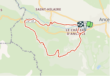

Length
9.3 km

Max alt
1427 m

Uphill gradient
253 m
Km-Effort
12.7 km

Min alt
1270 m

Downhill gradient
254 m
Boucle
Yes
Creation date :
2017-08-05 00:00:00.0
Updated on :
2019-05-28 16:50:04.07
2h43
Difficulty : Unknown

FREE GPS app for hiking
 SityTrail
IGN / Geographical institutes
SityTrail Plus
The world is yours!
About
Trail Walking of 9.3 km to be discovered at Provence-Alpes-Côte d'Azur, Hautes-Alpes, Ancelle. This trail is proposed by Rangabe.
Positioning
Country:
France
Region :
Provence-Alpes-Côte d'Azur
Department/Province :
Hautes-Alpes
Municipality :
Ancelle
Location:
Unknown
Start:(Dec)
Start:(UTM)
277675 ; 4944437 (32T) N.
Comments