


randonnée vtt labatut

jibus90
User
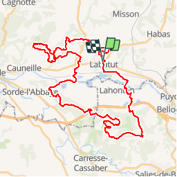

Length
51 km

Max alt
159 m

Uphill gradient
1039 m
Km-Effort
64 km

Min alt
9 m

Downhill gradient
1040 m
Boucle
Yes
Creation date :
2018-09-30 18:57:39.523
Updated on :
2018-09-30 18:57:39.562
3h43
Difficulty : Difficult

FREE GPS app for hiking
 SityTrail
IGN / Geographical institutes
SityTrail Plus
The world is yours!
About
Trail Mountain bike of 51 km to be discovered at New Aquitaine, Landes, Labatut. This trail is proposed by jibus90.
Description
Super. que des singles. En enlevant 20mn d'arrêt sur 3 ravitos, ça fait presque du 15km/h avec Martin (14ans). que du bonheur cette randonnée
Positioning
Country:
France
Region :
New Aquitaine
Department/Province :
Landes
Municipality :
Labatut
Location:
Unknown
Start:(Dec)
Start:(UTM)
662849 ; 4824172 (30T) N.
Comments
La rando parait intéressante mais en mai 2019 plein de chemins sont soit impossibles soit disparus soit interdits soit envahis de végétation donc circuit infaisable tel quel...