


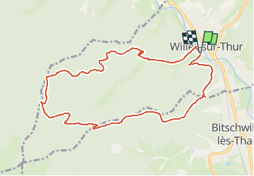
Parking terrain de foot à Willer - Abri du Blaufels- Chemin de l' Altrain Sud et retour

patrickbeyrath
User

Length
9.9 km

Max alt
815 m

Uphill gradient
473 m
Km-Effort
16.3 km

Min alt
366 m

Downhill gradient
479 m
Boucle
Yes
Creation date :
2018-10-13 05:52:01.714
Updated on :
2018-10-13 05:52:01.723
3h26
Difficulty : Medium

FREE GPS app for hiking
 SityTrail
IGN / Geographical institutes
SityTrail Plus
The world is yours!
About
Trail Walking of 9.9 km to be discovered at Grand Est, Haut-Rhin, Willer-sur-Thur. This trail is proposed by patrickbeyrath.
Positioning
Country:
France
Region :
Grand Est
Department/Province :
Haut-Rhin
Municipality :
Willer-sur-Thur
Location:
Unknown
Start:(Dec)
Start:(UTM)
355528 ; 5300583 (32T) N.
Comments