


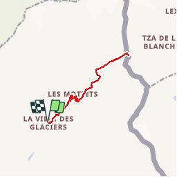
17-08-17 les Chapieux - Col de la Seigne

annefrance70
User

Length
11.9 km

Max alt
2511 m

Uphill gradient
752 m
Km-Effort
22 km

Min alt
1775 m

Downhill gradient
752 m
Boucle
Yes
Creation date :
2018-11-11 15:19:51.327
Updated on :
2018-11-11 15:19:51.453
4h28
Difficulty : Medium

FREE GPS app for hiking
 SityTrail
IGN / Geographical institutes
SityTrail Plus
The world is yours!
About
Trail Walking of 11.9 km to be discovered at Auvergne-Rhône-Alpes, Savoy, Bourg-Saint-Maurice. This trail is proposed by annefrance70.
Photos


Positioning
Country:
France
Region :
Auvergne-Rhône-Alpes
Department/Province :
Savoy
Municipality :
Bourg-Saint-Maurice
Location:
Unknown
Start:(Dec)
Start:(UTM)
326274 ; 5066216 (32T) N.
Comments