Trail Other activity Saint-Izaire - Circuit pédestre du St-Affricain

Circuit pédestre du St-Affricain "Saint-Izaire" (n°6)

 tbrunet
tbrunet

User

© OpenStreetMap contributors
Length
Length
10 km
Max alt
Max alt
478 m
Uphill gradient
Uphill gradient
338 m
Km-Effort
Km-Effort  
14.5 km
Min alt
Min alt
259 m
Downhill gradient
Downhill gradient
338 m
Boucle
Boucle
Yes
Creation date :
2017-08-19 00:00:00.0
Updated on :
2017-08-19 00:00:00.0

(0 Reviews)

Other activity
Other activity
--
Difficulty : Unknown

Scan this QR Code to open this trail in the SityTrail application

FREE GPS app for hiking

Logo SityTrail SityTrail

IGN / Geographical institutes

Download SityTrail from the App Store Download SityTrail from Google Play

Logo SityTrail SityTrail World

The world is yours!

Download SityTrail from the App Store Download SityTrail from Google Play Download SityTrail on Huawei AppGallery

About

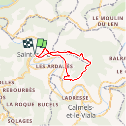
Trail Other activity of 10 km to be discovered at Occitania, Aveyron, Saint-Izaire. This trail is proposed by tbrunet.

Description

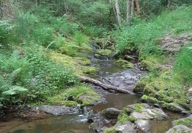
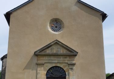
Difficulté : Moyenne, Distance : 10 km, Dénivelé : 230 m.Au départ de Saint-Izaire, charmant village dominé par un château épiscopal, ce parcours vous emmènera dans les tunnels de l'ancienne voie ferrée (prévoir éclairage). Vous découvrirez aussi une jolie mare, une statue-menhir, le Bois Noir, la chapelle Notre Dame de Grâce.Retrouvez à l'Office de Tourisme la collection complète des fiches de randonnée pédestre (6), équestre (1) et VTT (12).NB : fiches individuelles sur papier plastifié, avec fond de carte IGN, descriptif précis du parcours (2€ l'unité, tarif spécial pour le lot complet des fiches VTT : 10€)

Elevation profile

Points of interest

Point of interest Saint-Izaire - Point de Départ - Photo
tbrunet
SAINT-IZAIRE 
Point of interest Saint-Izaire - Étang des Canacs - Photo
tbrunet
SAINT-IZAIRE 
Point of interest Saint-Izaire - Statue-menhir - Photo
tbrunet
SAINT-IZAIRE 

Positioning

Country:
France
Region :
Occitania
Department/Province :
Aveyron
Municipality :
Saint-Izaire
Location:
Unknown
Start:(UTM)
477613 ; 4869106 (31T) N.

Trails nearby

Trail Walking Broquiès - La Cazotte Le Perayrol - Photo
Walking
Rere1947

Walking

Broquiès, Occitania, Aveyron, France
18.2 km | 24 km-effort
6h 24min
Yes
Trail Walking Saint-Izaire - st izaire - Photo
Walking
nanie

Walking

Very easy
(1)
Saint-Izaire, Occitania, Aveyron, France
13.1 km | 19.6 km-effort
5h 55min
Yes
Trail Walking Broquiès - Broquiès et la Vallée du Tarn - Photo
Walking
tracegps

Walking

Difficult
Broquiès, Occitania, Aveyron, France
18.9 km | 29 km-effort
5h 45min
Yes
Trail Walking Saint-Izaire - Saint Izaire - Photo
Walking
Frayssinet

Walking

Very difficult
Saint-Izaire, Occitania, Aveyron, France
19.5 km | 29 km-effort
6h 37min
Yes
Trail Walking Saint-Izaire - st izaire douce - Photo
Walking
CASSISFRAMBOISE

Walking

Easy
Saint-Izaire, Occitania, Aveyron, France
8.5 km | 12 km-effort
1h 55min
Yes
Trail Walking Calmels-et-le-Viala - Viala Cagné Tournet Sounpette Ruminier le Moulin le Viala - Photo
Walking
Bernard Constans

Walking

Difficult
Calmels-et-le-Viala, Occitania, Aveyron, France
8.9 km | 13 km-effort
2h 57min
Yes
Trail Walking Saint-Izaire - Saint izaire  2023 - Photo
Walking
Frayssinet

Walking

Very difficult
Saint-Izaire, Occitania, Aveyron, France
22 km | 32 km-effort
7h 11min
Yes
Trail Walking Broquiès - circuit de nouals - Photo
Walking
yvesmonteillet

Walking

Very difficult
Broquiès, Occitania, Aveyron, France
13 km | 19.2 km-effort
2h 51min
Yes
Trail Walking Broquiès - circuit saint cyrice - Photo
Walking
yvesmonteillet

Walking

Difficult
Broquiès, Occitania, Aveyron, France
12.8 km | 18.7 km-effort
4h 24min
Yes


Close
My subscriptions